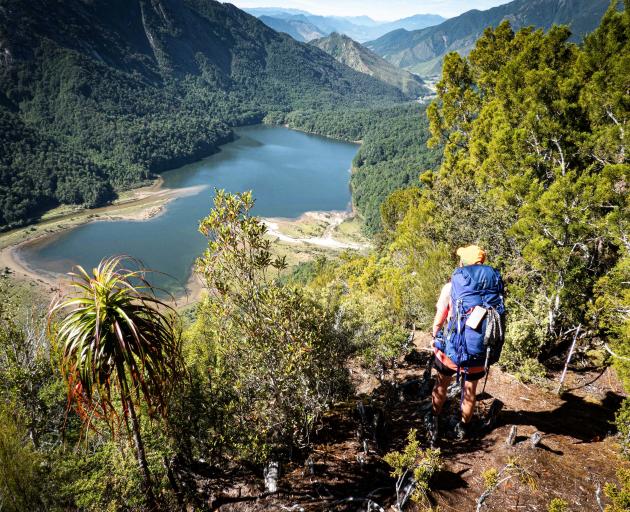
Rudy Adrian discovers little-known Lake Matiri on the West Coast.
"Welcome to the West Coast" - that’s the message I get from a farmer who gives me a friendly wave as I drive past. I’m just a tourist travelling along a gravel road off State Highway 65, near Murchison. I’m almost exactly halfway between Westport and Nelson, and heading to Lake Matiri.
Maps show the lake sitting at the edge of Kahurangi - New Zealand’s largest national park, which stretches from the Buller River in the south, all the way to Golden Bay in the north, taking in range after range of rugged hill country.

The first time I learned about Lake Matiri was an article in a Nelson newspaper more than 40 years ago. The lake was described as being as a pleasant walk away from the standard tourist trail.
Not far from the main road, my car journey ends at a locked gate and an empty car park. From here, the lake is an easy 3km walk, mostly along a narrow gravel road that was created recently for a small hydro-electric scheme on the Matiri River. Near the car park is a small automated power station, quietly using water piped down from the lake to spin a single turbine, putting electricity into the national grid and the water back into the river.

Pioneer Energy general manager contracting Peter McClean later tells me the new bridge has significantly improved visitor access to the area.
"Every few weeks during the construction we had people coming up and saying ‘This is amazing, we haven’t been up here before’."
I walk along the road, with its occasional overhanging beech tree boughs, while just below me is the Matiri River - a boiling surge of water rushing between boulders the size of houses.
The surrounding forested hills show jagged scars and slips, testament to a succession of earthquakes such as the Murchison in 1929 and the Inangahua in 1968.

However, a bigger quake occurred here in 1717, when the Alpine Fault ruptured, uplifting the mountains several metres.
It is likely that quake also triggered a large landslide that blocked the river and created Lake Matiri, only 300 years ago.
As I walk up the valley, I come across signs advising me not to dawdle because of a more recent and still active slip, from which rocks might still tumble down at any time. Indeed, I can see evidence of very recent falls, where rocks the size of baseballs, and even larger, have smashed on the road.
Keeping an eye on the slope above, I scoot past and head deeper into the Matiri Valley.
Eventually the surrounding beech forest starts to cloak the road. The water pipeline, which has so far been buried under the road, reveals itself, looking like a large black serpent, winding through the beech trees.
After travelling some distance through the forest, the pipeline swerves off to the intake weir at the mouth of the lake, and my route onwards is reduced to a rough walking track.
Between the trees, I finally start to catch glimpses of a large body of water, fully revealing itself as Lake Matiri once I pass the unoccupied eight-bunk Lake Matiri Hut.

The track continues on to other huts and lakes deep in Kahurangi National Park, but this is as far as I’m going on my half-day walk.
The water laps gently on the lake shore, with the occasional call from a paradise shelduck being the only other sound. Unlike the popular walks at nearby Lake Rotoiti or Lake Daniels, this is truly a rarely visited spot, yet not far off the highway to Nelson. More than 40 years after reading about it in a local newspaper, I’m pleased to have finally arrived.


