The online map finally became accessible to the public yesterday after it was closed down on Monday by a cyber attack, which police are investigating.
Although the main coastal areas of Dunedin, Invercargill and Oamaru were not expected to have sea levels rise much earlier, other small communities along the region’s coastline would.
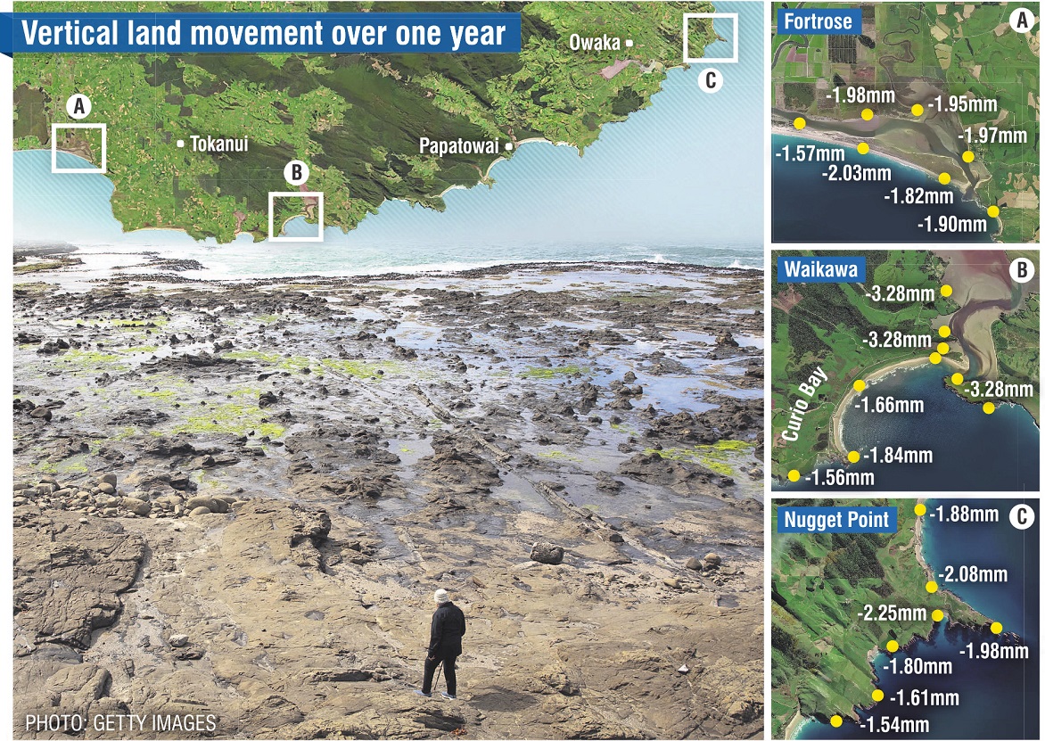
NZ SeaRise maps show much of the South Otago and Catlins coastline is subsiding, meaning sea-level rise will come earlier than predicted.
Sea levels across the globe are rising at 3.5mm a year.
At the same time, seismic activity is causing parts of Nugget Point, in South Otago, to sink up to 2.08mm a year. It is one of the fastest sinking areas in Otago and Southland.
By the end of the century, the sea level will have risen by 56cm and the ground around Nugget Point will have dropped by 77cm.
So those on land less than 1.33m above sea level, will be getting wet feet by 2100.
In the Curio Bay/Waikawa area of the Catlins, land is subsiding by 3.28mm a year.
By 2100, the sea level is expected to rise by 56cm and the land is expected to sink by 88cm.
And in Fortrose, Southland, land is dropping at 1.97mm a year. Sea-level rise is expected to be 56cm, while land is expected to drop by 76cm over the same timeframe.
Affected to a lesser extent are areas such as Sawyers Bay, in Dunedin, which is dropping 1.15mm a year, and areas north and south of Oamaru which are dropping up to 1.4mm a year.
While the land around Dunedin Railway Station is subsiding, it is only dropping by 0.44mm a year, meaning it has low vertical land movement, and is unlikely to have sea-level rises earlier than already predicted.

He said it would affect the petrified forest and about 30 houses in the Curio Bay community alone.
"Day to day, there’s not a lot of effect at the moment. But in the higher tides, certainly there’s noticeable changes already.
"I’m not disputing [these projections] at all."
He said the houses were already on foundations about 2m-3m above sea level, and as the sand dunes eroded, it would bring the sea much closer.
"It’s not feasible in a place like Curio Bay to be building sea walls to avoid it. Certainly, it’s an issue to be thinking about."
He said he was not confident the world would slow sea rise at this stage.
"Fighting sea-level rise, everyone on the planet’s got a part to play in that.
"But we’re not showing a lot of momentum so far, and God knows what we’re doing to carbon in the atmosphere in Ukraine and Russia at the moment.
"The pace of change, in terms of the climatic change we’re seeing around the world, and the speed with which we are putting things in place, don’t match. Reality is a great reason to react."
Fortrose Cafe owner Emily Butters was not shocked by the projections for her community.
"We’re already seeing it. We’re not even 30cm above sea level. We can walk across the road at high tide and basically the water can be right there."
She believed the road would be under water within the next decade and would affect about 20 houses in the community.
NZ SeaRise project co-leader and Victoria University of Wellington earth sciences professor Tim Naish said continuous seismic events were adding up to cause subsidence in many parts of New Zealand, and the new projections showed the annual rate of sea-level rise could double.
For many parts of New Zealand’s coast, 30cm of sea-level rise was a threshold for extreme flooding, above which the 100-year coastal storm becomes an annual event, he said.
Comments
So, part of the problem is the land level dropping, a phenomena known in other parts of the world for decades. The move towards EVs will add to this problem as they are heavier than traditional ICE vehicles. Oh what a conundrum:)
This math is not clear to me. It is 78 years remaining until the end of the century (2100). Rising seas should bring 3.5mm x 78= 27cm. The impact of the Nugget Point sinking (against what reference point by the way?) will bring 2.08mm x78 = 16cm. This will result in a subduction of 43cm in total, not 1.33m.
Funny, they've been saying that for 50 years now. According to them, my house should be under water by now. Surprisingly, it's not.


