You could be forgiven for thinking it's Groundhog Day. Just like this time last week, snow was falling in parts of the South, bringing chilly winds also.
Another cold snap is sending shivers through the South, set to bring snow to all alpine passes in the South Island on Wednesday.
MetService said with southwesterlies continuing to dominate over New Zealand for the next few days, daytime temperatures would be on the cold side - even for this time of year.
It'll be chilly few days in Dunedin, as the city's maximum temperatures won't reach double digits until Friday, while sub-zero minimum temperatures will be the norm for many inland areas until the weekend.
The forecaster this afternoon issued fresh snowfall warnings for Dunedin's Northern Motorway (State Highway 1 to Waitati), the Crown Range Road, linking Queenstown and Wanaka, the Lindis Pass (SH8) and Southland's Milford Road (SH94) from Wednesday morning.
Snow was forecast to lower to 400 metres on the Northern Motorway from 9am and gradually down to 200 metres by 7pm, with up to 2cm of snow settling on the summit at times.
Meanwhile, a heavy snow watch has been issued for Otago, south of a line Queenstown to Mosgiel, also Fiordland and Southland from 9am until 6pm. Snow was expected to about 200 metres, with heavy falls above 400 metres where accumulations may approach warning criteria.
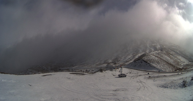
Snow fell overnight on the Crown Range and there were flurries this morning. On Wednesday, snow was set to affect the road for a time, with up to 6cm expected to settle near the summit between 7am and 6pm.
In Southland, up to 8cm of snow was forecast for the Milford Road, while the Lindis Pass was set to get up to 4cm at the summit.
Waka Kotahi/NZ Transport Agency advised that as snow was likely to affect the Milford Road until Thursday, road users should take extra care due to snow clearing work during the day. Chains must be carried overnight from 10pm on Tuesday.
Heavy snow likely for Canterbury and Buller
The biggest falls will be further up the South Island, with MetService warning that up to 25cm of snow is predicted for alpine roads the Lewis, Arthur's and Porters passes from Wednesday night until Thursday morning.
A heavy snow warning is also in place for inland Canterbury about and north of Arthur's Pass, Marlborough south of Ward and Nelson Lakes National Park, with between 20cm to 30cm of snow expected above 300 metres, with lesser amounts to 100 metres from 6pm on Wednesday until 8am on Thursday.
Heavy snow may disrupt travel in affected areas and could damage trees and powerlines. Cold conditions may cause stress for livestock.
Meanwhile, a heavy snow watch is in place for inland Canterbury, south of Arthur's Pass, from 4pm on Wednesday until 1am on Thursday, with snow is expected to about 200 metres, with heavy falls above 400 metres where accumulations may approach warning criteria.
And a watch has also been issued for Buller and western parts of Tasman from 11pm on Wednesday until 9am on Thursday, with snow forecast to about 300 metres, with heavy falls above 500 metres where accumulations may approach warning criteria.
Series of cold fronts
MetService meteorologist Mmathapelo Magabutlane said there would be a few showers, falling as snow above 300m today, accompanied by cold southwesterlies.
"Those in hilly areas can expect some snowfall - including Dunedin. In terms of amounts of snow, it doesn’t look to be too much, but going in to Wednesday and Thursday it looks like there could be heavier snow."
The cold front was expected to sweep northwards over the South Island on Wednesday, bringing a period of cold southerlies and snow to low levels about central and southern New Zealand, she said.
"In the South Island, snow is expected to fall to 300m to 400m or possibly lower in the South."
It was possible snowfall would reach warning criteria above 500m around southern Fiordland, Central Otago and inland Dunedin, she said.
"The weather system that we’ve got at the moment is a series of cold fronts that just keep coming through, and each front brings in progressively colder air, so it’s just cold on cold on cold.
"As soon as we start getting rain showers, that’s when we start to see snow in those hilly areas.
"I feel like at this time of year, when the weather comes in waves and cycles, you know Sunday will be a clear day, Monday it starts getting chilly, Tuesday is the big front day, and round it goes. Here we go again."
A ridge of high pressure was expected to move over New Zealand later on Thursday and Friday, before fronts spread on to New Zealand from the Tasman Sea on Saturday, she said.
At this stage, Saturday looks mainly fine in the South, but later on Sunday, another snow-bearing front was looking likely.
Chilly, frosty start in Queenstown and Central
A spokesman for the Queenstown Lakes District Council said there were wet roads and freezing temperatures across the network early this morning, with sections of ice that crews had gritted.
The Crown Range, linking Queenstown and Wanaka, had road ice across the entire alpine section that had been extensively gritted and road users should allow extra time for travel, slow down and drive with caution, he advised.
"Some temps are hovering just above freezing in the Wakatipu/Kingston area, with rain beginning to fall in places. Wanaka to Haast, Lindis Pass and State Highway 85 to Ranfurly all with temps below zero with grit applied in isolated spots."
Grit had been also been placed on Wanaka Mt Aspiring Rd, with temperatures at -2degC in the Wanaka area down to -4degC at Hawea Flat earlier this morning, the spokesman said. Temperatures in the Wakatipu Basin were hovering around freezing, so watch for ice and grit in shady damp areas around Arthurs Point, Littles Rd, Speargrass, Domain and Malaghans. Glenorchy has damp roads with frosty sections and grit had been placed around Closeburn Hill and Bobs Cove.
It was another frosty start to the day in Central Otago, with temperatures ranging from -3degC to 4degC, but roads were dry, a spokesman for the Central Otago District Council said.
However, caution was advised on bridge decks and shaded areas and crews would continue to monitor roads throughout the morning. Danseys Pass Road was closed (from the gates past the Danseys Pass Hotel) due to snow and ice.
Road snowfall warnings
Dunedin to Waitati Highway (SH1)
Period: 9am until 7pm on Wednesday
Snow forecast to lower to 400 metres in the morning and gradually down to 200 metres by the evening. Expect 1 or 2 cm of snow may settle on the summit of the road at times, with lesser amounts down to lower levels.
Crown Range Road
Period: From 7am until 6pm on Wednesday
Snow set to affect the road during this time. Expect 3cm to 6cm to settle on the road near the summit, with lesser amounts down to lower levels.
Milford Road (SH94)
From 2am until 11pm on Wednesday
Snow is forecast to lower to 800 metres early in the morning, then gradually lower to 300 metres in the afternoon and evening while snow should clear west of the Homer Tunnel. From 2am to 8am, expect 2cm to 4cm of snow above 800 metres. From 8am until 11pm, expect an additional 2cm to 4cm of snow to settle on the road above about 300 metres, mainly south of Lake Gunn.
Lindis Pass (SH8)
Period: from 8am until 6pm on Wednesday
Snow to affect the road during this time. Expect 2cm to 4cm to settle on the road near the summit, with lesser amounts down to 400 metres.
Haast Pass (SH6)
Period: From 9am until 1pm on Wednesday
Brief period of snow is forecast to affect the road during this time. Expect up to 2cm of snow to settle on the road above 500 metres.
Porters Pass (SH73)
Period: from 5pm on Wednesday until 3am on Thursday
Snow forecast to lower to 500 metres on Wednesday evening. Expect 15cm to 25 cm of snow to settle on the summit, with lesser amounts down to 500 metres.
Arthur's Pass (SH73)
Period: from 5pm on Wednesday until 3am on Thursday
Snow to lower to 500 metres on Wednesday evening. Expect 15cm to 25 cm of snow to settle on the summit, with lesser amounts down to 500 metres.
Lewis Pass (SH7)
Period: From 7pm on Wednesday until 8am on Thursday
Snow expected to lower to 400 metres on Wednesday evening. Expect 15cm to 25 cm of snow to settle on the summit, with lesser amounts down to 400 metres. There could be a brief period of snow on Tuesday evening where 1cm could accumulate near the summit.
john.lewis@odt.co.nz
- Additional reporting by ODT Online