
Heavy rain has fallen in the Otago headwaters in recent days: in the Upper Clutha River catchments and in the headwaters of Central Otago rivers, including the Kawarau River, the Shotover River, the Lindis River, the Manuherikia River and the Kye Burn/upper Taieri River.
On Wednesday morning several stretches of highway were still closed but by 6pm all major highways had reopened.
Lindis Pass was the last to reopen but speed restrictions are in place due to ongoing surface flooding, potholes and flood damage.
Haast Pass (State Highway 6) reopened at about 3pm after the road was cleared of fallen trees. An area warning remains in place and drivers are urged to take extra care on the route.
Omarama has two state highway connections again, with SH8 to Twizel reopening after 10am and SH83, Otematata to Omarama, opening before 11am.
The third, key route to Omarama - the Lindis Pass - remains closed as there are a number of slips and damage to clear.
The Mount Cook road (SH80) reopened about 1.15pm with stop/go management in place, Waka Kotahi NZ Transport Agency said this afternoon. The road was scheduled to be closed overnight from 6pm to 7am tomorrow.
Graeme Hall, System Manager for Waka Kotahi, said people would have a slower-than-usual journey on many Otago and Canterbury roads because of the damage.
"People should expect surface flooding in places and drive to the conditions especially around our road crews and stop/go people," Mr Hall said.

"The alternative route into Central Otago is via SH85 - Palmerston, Kyeburn and Alexandra. The coastal end of this route is damaged from the recent snow and floods so please factor that into your journey. There are also potholes and damage on SH87, Mosgiel to Kyeburn.
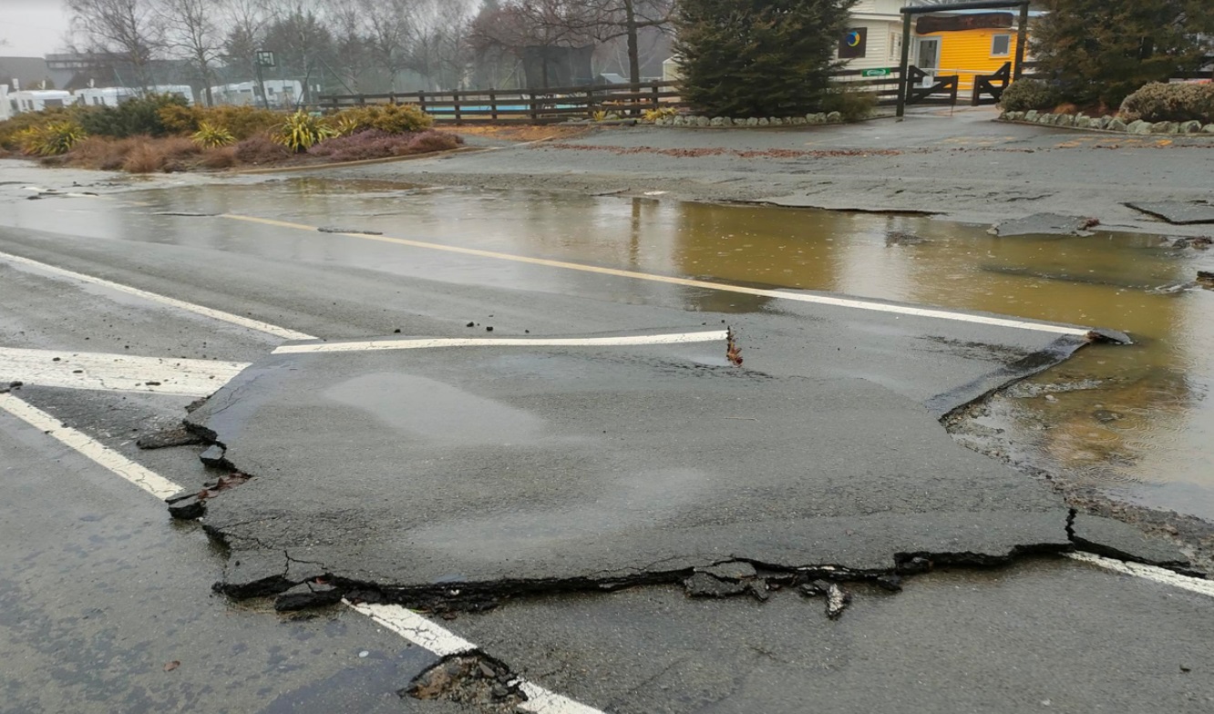
Speed restrictions were still in place on some stretches of highway at midday, and closures on a raft of minor roads in the Maniototo area (scroll to bottom of story to see closures).
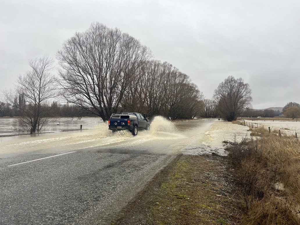
Waka Kotahi NZ said caution was required in many places due to ongoing surface flooding, potholes and flood damage.
Further south, the Gore District Council says the Mataura River has risen significantly overnight, and several roads are closed around the city. The river was expected to start dropping soon, and roads could reopen later this morning.
The Otago Regional Council was yesterday urging people to be cautious around rivers and low-lying land as waterways around Central Otago and the upper Clutha catchments rise.
Mr Hall said slips and rockfalls would continue this week. He told RNZ that wind and rain closely following heavy snowfall had been a destructive combination.
Drivers should expect ice and snow on the roads today and Hall urged anyone out on the roads to drive slowly.
"It's the worst it has been for a number of years."
Haast Pass was closed owing to fallen trees, rock slips, flooding and strong winds.
An Aspiring Highways representative said a "couple of diggers had been sent to clear the road and assessments were being done between Makarora and Hawea."
Makarora resident Jim Arthurs said yesterday weather over the past 48 hours had varied.
"We had a huge thunderstorm last night. A lot of internet routers fried, and lots of new lakes are forming on farms," he said.
The Haast-Hawea section of SH6 was open to Makarora residents yesterday, but closed to the general public from 7am.
Last night, SH8 through Alexandra was the only route open to SH1 for northbound travel out of Central Otago.
The downpour caused roads and walking tracks to close as the Manuherikia River breached its banks near Omakau, Ophir and Galloway, flooding low-lying farmland.
A boil water notice was issued for Omakau and Ophir, and Ophir residents were advised to keep a sharp watch on river levels.
The highest previous flow recorded for the Manuherikia River at Ophir, since 1971, was 602 cumecs in December 1995.
Otago Regional Council natural hazards manager Dr Jean-Luc Payan said the Manuherikia River at Ophir reached its peak about 4pm yesterday and, while high, had begun to fall.
The main rivers in Southland were all running above normal and there were reports of localised flooding.
Further north, the Ashburton River broke its banks and flooded some farmland, as heavy rain swelled Canterbury rivers.
Canterbury Civil Defence Emergency Management was monitoring key rivers and warned the main impact of the rainfall would be seen late yesterday and overnight.
MetService forecaster Gerard Bellam said the South had "seen the worst" of the rain and today it would ease to light rain.
However, a low was deepening to the east and by tomorrow southerlies would bring cold temperatures.
Coastal areas would feel the worst of the effects and there could be large swells, he said.
Central Otago road closures
As at 7.30am on Wednesday, information from CODC
- Galloway Road – OPEN (Galloway Bridge to Fisher Lane) Caution advised as still some surface flooding,
- Danseys Pass Road – CLOSED (from the gates past the Danseys Pass Hotel) due to ice/snow,
- Naseby Link Road – CLOSED (SH85 to Naseby Gimmerburn Rd intersection) due to flooding,
- Auripo Road – CLOSED (Boundary Rd to Thurlow Rd) due to flooding,
- Reef Road – CLOSED (At the Reef Rd Ford) due to flooding,
- Mt Buster Road – CLOSED (from Danseys Pass Rd)
- St Bathans Downs - CLOSED ( SH 85 to Beattie Rd) due to flooding,
- Ida Valley Omakau Road – OPEN (SH85 to Swindon St intersection).
Gore road closures
As at 1.15pm
- Woolwich St - Huron St to Boundary Road
- Maitland St – from the stop bank west
- River Road - Heaps Road to Old Coach Road
- River Street - Clover Export’s plant to Salford St


