
Otago Regional Council (ORC) staff have been ‘‘activated’’ and will be on duty over Labour Weekend, monitoring streams, rivers and lake levels across the region and updating relevant councils about any forecast flooding concerns.
Expectations of heavy rainfall and the possibility of unseasonable snow to lower levels across Otago tomorrow have prompted the ORC to reiterate MetService’s call to be prepared.
MetService earlier urged Dunedin residents to be prepared for possible flooding over the holiday weekend, as a large area of low pressure looks to drop more heavy rain along coastal Otago.
Meteorologist Clare O’Connor said a large area of low pressure was expected to cover the South Island tomorrow, and heavy rain or showers were likely to affect many areas, with heavy snow about the South Island high country.
ORC science and resilience general manager Tom Dyer this afternoon said a front heading north up the West Coast was expected to loop over the Southern Alps and come back down into Central Otago, North Otago and possibly coastal areas, from noon tomorrow through to a peak about midnight tomorrow.
"While the weather has been relatively benign around most of Otago for the past few days, heavy rain is expected, which could cause ponding or minor surface flooding in some areas," he said.
"There is also unseasonal snow forecast to above 600 metres inland, but there’s potential it could lower to around 400m or less in some areas."
Rain in Otago during the day was expected to total 30mm-50mm, falling ‘‘steadily’’ at about 5mm per hour.
Dyer said that was unlikely to trigger alerts, but the still sodden ground from the October 3-6 flooding in coastal Otago and some inland areas was the concern.
‘‘The rainfall is likely to sheet off the land directly into waterways, which then poses the problem of accumulation and possible surface flooding,’’ he said.
MetService earlier today issued a slew of weather alerts, including heavy rain watches for Dunedin, North Otago and the Queenstown Lakes District, and an orange heavy snow warning for Central Otago, Queenstown Lakes, and the Canterbury High Country south of the Rangitata River.
The forecaster says most alpine passes will be affected snow - between 10cm and 40cm has been forecast for state highways including the Crown Range, the Lindis Pass (State Highway 8) and the Milford Road (SH94).
The Dunedin City Council said it would be keeping an eye on the situation.
"If there are any major updates, these will be posted to our social media and website at dunedin.govt.nz"
Dyer said motorists should expect deteriorating conditions, and urged people to take care when encountering fords and waterways.
“If in any doubt, don’t attempt to cross swollen rivers.”
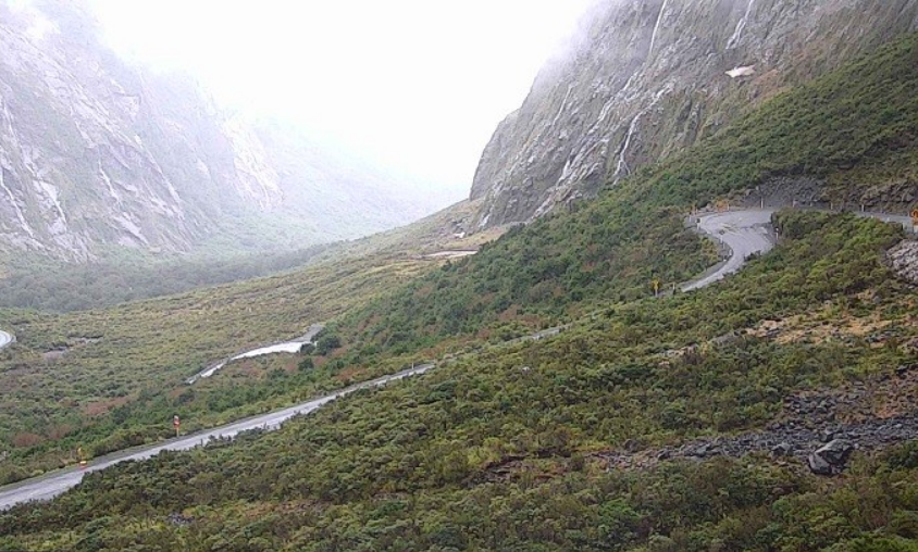
Care needed on Milford Road
The Milford Road in Southland reopened at 10am today after being closed since noon on Wednesday due to a heightened risk of avalanche.
Though the avalanche risk is low on Friday, care is needed on SH94 over Labour Weekend, Milford Road Alliance advised.
Snow is forecast from Knobs Flat to The Chasm from dawn on Saturday, and the highway will close mid-afternoon. It may reopen about mid-afternoon on Sunday.
Heavy snow warning, rain watches
An orange heavy snow warning is now in place for Central Otago, Queenstown Lakes, and the Canterbury High Country south of the Rangitata River for 24 hours from midnight on Friday.
MetService says to expect 20 to 40cm of snow to settle above 600 metres, with lesser amounts down to 400 metres.
There are also heavy rain watches in place for Dunedin and North Otago from 9am to midnight on Saturday, and for the Queenstown lakes District for 18 hours from 6am to midnight on Saturday.
On Sunday, the large area of low pressure was expected to remain over the South Island, and it was possible the heavy rain would continue to affect South Canterbury and eastern Otago on Sunday, requiring a further heavy rain warning.
By Monday, the low should have weakened and moved out east of New Zealand, leaving much of Otago and Southland with showers and light winds.
Ms O’Connor said if people were travelling out of town this weekend, they should drive to the conditions, allow extra time to get there, avoid travelling at night, and watch for surface flooding, slips and fallen trees or branches.
"Also, before you leave home, make sure your house is prepared for heavy rainfall.
"Make sure your drains and gutters are clear, and make sure your house is ready for severe weather."
Road warnings
MetService late this evening issued road snowfall warnings for most of the alpine passes in the South Island.
Arthurs Pass (SH73)
Valid: 16 hours from 2am Saturday to 6pm Saturday.
Forecast: Snow expected from early Saturday morning until Saturday evening. 20 to 40cm may accumulate on the road above 600 metres.
Porters Pass (SH73)
Valid: 16 hours from 2am Saturday to 6pm Saturday.
Forecast: Snow expected from early Saturday morning until Saturday evening. 10 to 20cm may accumulate on the road above 600 metres.
Haast Pass (SH6)
Valid: 16 hours from 2am Saturday to 6pm Saturday.
Forecast: Snow is expected from early Saturday morning until Saturday evening, mainly from the summit southwards. 2 to 4cm may accumulate on the road above 500 metres.
Lindis Pass (SH8)
Valid: 17 hours from 3am Saturday to 8pm Saturday.
Forecast: Snow expected from early Saturday morning until Saturday evening. 10 to 20cm may accumulate on the road above 500 metres.
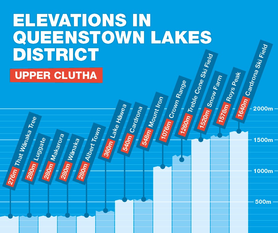
Crown Range Road
Valid: 21 hours from 3am Saturday to 12am Sunday.
Forecast: Snow expected from early Saturday morning until Saturday night. 20 to 30cm may accumulate about the road above 500 metres.
Milford Road (SH94)
Valid: 20 hours from 4am Saturday to 12am Sunday.
Forecast: Snow expected from early Saturday morning until Saturday night. 15 to 25cm may accumulate on the road above 500 metres.
- additional reporting ODT Online


