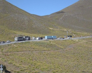
Motorists upset by regular hold-ups on State Highway 6 at the Nevis Bluff in the Kawarau Gorge are asking why a permanent fix can't be found to stop the instability which at times sends huge rocks raining down on the highway. The NZ Transport Agency took Tracey Roxburgh of the Otago Daily Times high above the area to explain why there is no simple ''fix'' for the problem.
In September 2000 a group of motorcyclists started riding down the highway between Cromwell and Queenstown on a Sunday morning.
Later a contractor told Transit New Zealand about 11 o'clock the night before he had noticed some rocks on the road beneath the Nevis Bluff.
He thought nothing of it.
Cruising past the Nevis Bluff about 10am, the motorcyclists came within seconds of being killed when a catastrophic failure of the bluff caused 10,000cu m of rock to come tumbling down its face.
The group was separated on either side of the blocked highway. Remarkably, no-one was killed or injured.
For Transit New Zealand - now the New Zealand Transport Agency - it was a wake-up call.
The previous major failure at the bluff in 1974 let loose 30,000cu m of rock that detached from the bluff, again blocking the highway.
Opus International Consultants Ltd project engineer Reece Gibson said that event, the largest in the bluff's history, resulted in a monitoring programme by the Ministry of Works, which continued until about 1983.
NZTA Central Otago area manager John Jarvis said Transit New Zealand was formed in 1989, taking over the role of monitoring the highways and at-risk areas from the ministry.
''There was a time when nothing formal was done [at the Nevis].
''We hadn't noticed any real significant issues at all - I think people felt more comfortable that things were OK because nothing had happened.''
Just before the 2000 event, Transit had started inspecting the bluff and identified the feature that later fell as being ''at risk''.
Before Transit had time to deal with it, the feature failed ''out of the blue''.
It took several weeks for the road to be cleared, at a cost of about $2.5 million and prompted Transit to step up its monitoring to prevent further failures of the bluff.
It is a programme which has cost an average of $400,000 a year since 2000. And, it often causes delays to motorists.
The work includes monthly helicopter inspections and twice-yearly detailed abseiling inspections of the bluff, including small rock removals.
When major problems are detected, NZTA wastes no time in applying for funding for stabilisation work.
Since 2000, the agency has carried out three major safety programmes at the site, each costing over $1 million.
The present programme, which began in March, is the most extensive.
It has a $1.3 million budget and has included rock-blasting using explosives, monsoon buckets, hand-scaling, hydraulic-jacking and air bags to remove about 600cu m of loose rock from two areas, known as Zeus Column and Cling On, both on the Queenstown side.
Staff from Geovert work about 170m above the highway, drilling large holes in Zeus Column and bolting the rock into place.
Mr Gibson said most of the work had been focused on the column to prevent a ''knee-joint failure'' - where pressure from an upper column of rock causes the centre of mass on the lower column to move outwards beyond the point of stability. The lower column fails, often collapsing the upper part too.
Last month Central Otago Mayor Tony Lepper called for a ''please explain'' meeting with NZTA to find out why there were so many delays for motorists. He said the delays were having a ''severe'' impact on the Central Otago economy.
The problem, Mr Jarvis said, was much bigger than most realised and the delays would be a continuing reality until a permanent solution was found.
Since 2001 NZTA had been working on that solution. Several options had been floated and all but two discounted.
The first was to bench or terrace the bluff, the second to tunnel through it.
Neither option was guaranteed to work.
Benching, or terracing, similar to work done in the Cromwell Gorge, but on a ''much bigger scale'', would mean the bluff was carved into steps to prevent further major rock falls.
The alternative - in some respects the most feasible - was to tunnel through the bluff.
A 650m-long tunnel, with a 10m diameter would cost an estimated $100 million ''at least'' and would need to be constructed in line with international best practice.
However, it would have a potential impact on freight cartage, particularly oversized loads, like houses.
Further, ''many consents'' would be required from various authorities, including the Otago Regional Council, Queenstown Lakes District Council and the Department of Conservation.
Consultation with landowners would be required and there was a likelihood NZTA would need to purchase land.
A full investigation, including geotechnical drilling, would be required - and to receive funding it had to be compared against every other major NZTA programme in New Zealand.
While a permanent fix would be years away, Mr Jarvis said the agency was looking to install either catch fences or bundles at parts of the bluff to catch smaller rocks as they fell - hopefully within the next three to five years.
It also planned to install permanent electronic signs, to service the Nevis Bluff and surrounding roads, like the Crown Range, at Cromwell and the Arrowtown side of the Crown Range to give updated messages on road conditions and likely delays.
The signs cost between $90,000 and $150,000 and needed to be in an area with cellphone coverage and sufficient land.
Mr Jarvis said the agency appreciated traffic delays could be frustrating, but ''travel time losses involved on an economic basis don't provide a strong enough prioritisation and business case for an option, such as a tunnel, to be supported in the short to medium term''.
''It's just like the Kawarau Falls Bridge - it's been going on for several years.
''I was involved in the investigations of that over 10 years ago ... we're still going through the design at the moment.
''These things take time.
''We'd have to do a lot more investigative work to progress that with any degree of certainty to even line it up for funding.
''We've got to demonstrate it could actually be achieved [and] it's cost-prohibitive at the moment.
''Even if we had the money available, there would be a considerable lead-in period to the investigations for one of those big options.
''At the end of the day, it's got to be weighed up against all of the priorities in the rest of the country.''
Unviable options at the Nevis Bluff
A rock shed: A concrete structure built over State Highway 6 at the Nevis Bluff, slanted towards the Kawarau River would be ineffective in big events, such as the 2000 slip.
A cantilevered half bridge/realigning State Highway 6 further into the Kawarau River: Foundation material beneath the road and on its edge is largely slip debris and therefore ''suspect'', causing concern either option would struggle to take the potential loadings.
Realign State Highway 6 to run over the bluff: NZTA would need to construct a ramp and cut through the back of the bluff to enable motorists to travel over it, with a possibility that road could be subject to similar issues with unstable rock, but to a ''bigger degree''.
A viaduct: Similar to that in the Otira Gorge, the viaduct option would carry a road above the Kawarau River. Described as ''extremely challenging'', it would affect recreational users of the river.
A suspension bridge: Also above the Kawarau River, it would come with a ''lot of issues''.
Bridging to the other side of the river: A popular option was to create two bridges either side of the bluff to divert traffic to the opposite side of the river. However, the Mount Michael slip made material at the base of the slip, where the road would be built, unstable.