Forecaster Niwa this morning issued a stark warning, saying the wintry blast was set to plunge the South Island to freezing levels, with wind chill making it feel anywhere from -5degC to -15degC.
It says this will threaten a "real hypothermia risk for people and livestock".
MetService said a sudden "Antarctic blast" would chill the country over the next few days, starting with a blast of cold polar air.
In Canterbury, the mercury was set to drop a staggering 15degC to 20degC within a matter of hours today.
MetService has issued a heavy snow watch for much of the South Island, leaving many high country farmers nervous about the impact the late wintry blast could have on lambing and calving.
The forecaster this morning updated its advisories to say that a watch applied to Marlborough south of the Clarence River, the Canterbury high country and foothills, North Otago, Central Otago from Alexandra northwards, and the Lakes District from Queenstown northwards, from 10pm today until midnight on Wednesday.
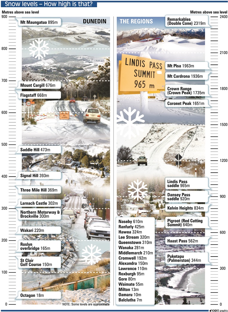
Further south, a watch was in place for Southland, Stewart Island, Clutha, Dunedin, Central Otago south of Alexandra, the Lakes District south of Queenstown, and Fiordland from Te Anau southwards, from 7pm today until 9am on Thursday.
MetService said for this more southern group, heavy snow above 600 metres was possible this evening. It said snow amounts may approach warning criteria above 600 metres about Central Otago south of Alexandra and the Southern Lakes District south of Queenstown.
From around 6am tomorrow until 9am on Thursday, snow showers were forecast to sea level, and snow amounts could reach warning criteria, in some places down to sea level.
MetService said parts of this watch could be upgraded to a warning.
Federated Farmers Otago president Mark Patterson said while most low-country farmers in Southland and Otago had now finished their lambing and calving seasons, high-country farmers were just beginning theirs.
"It’s more the high-country farmers that are just getting into their lambing now - they’ll be a bit nervous.
"An event like this, if it gets too bad, it will be concerning. They’ll be doing everything they can to make sure [stock are] well fed and in sheltered positions. It’s very much a wait-and-see-what-happens situation."
The storm had the potential to affect farm growth. "Obviously, for the horticulture people, the spectre of late frosts will be making them nervous as well."
Snow warnings for roads
Snow was likely to affect many roads and disruption to travel was likely across the South Island. People were advised to proceed with care and keep up to date with the weather forecasts and travel advice.
MetService late tonight updated snow warnings for all the South Island's alpine passes and for Dunedin's Northern Motorway (State Highway 1), the Crown Range Road (linking Queenstown and Wanaka) and the Milford Road (SH94).
Dunedin Northern Motorway
Snow showers were likely to affect the state highway from midday on Wednesday until 4am on Thursday. Between 4cm and 8cm of snow was likely to settle on the road down to sea level.
Crown Range Road
From 8pm Tuesday until 12am on Thursday: Snow is forecast to affect the road for a time on Tuesday evening and overnight, with 2cm to 4cm possibly settling on the road above 600 metres, and lesser amounts down to lower levels. During Wednesday, a further 2cm to 5cm of snow could settle between midday and midnight, mainly above 500 metres, but lesser amounts were likely down to the valley floor.
Milford Road
From 8pm on Tuesday until 3am on Thursday: Snow may affect higher parts of the road for a time. From 8pm until 11pm on Tuesday, up to 3cm of snow may settle on the road above 700 metres. Then from 9am to 3pm Wednesday, snow showers were expected to low levels, and 3cm to 6 cm could settle above 500 metres, with lesser amounts to lower levels. From 3pm on Wednesday until 3am Thursday, 2cm of snow may settle on the road to low levels south of Lake Gunn.
Lewis Pass (SH7)
From 5am to 10pm on Wednesday: A brief period of snow is expected to affect the road in the morning. Between 5am and 8am, 1 to 3 cm may settle above 700 metres. Then from 4pm to 10pm, a further 1 to 3cm could settle to low levels.
Arthur's Pass (SH73)
From 2am to 9pm on Wednesday: A brief period of snow is possible in the early hours of the morning, and between 2am and 7am, up to 3cm may settle on the road. Then from 4pm to 9pm, a further 2cm could settle.
Porters Pass (SH73)
From 2am to 9pm on Wednesday: A brief burst of heavy snow is possible in the early hours of the morning, and between 2am and 7am, 4cm to 8cm of snow may settle on the road. Then from 4pm to 9pm a further 2cm to 4cm could settle.
Haast Pass (SH6)
From 1pm to 5pm on Wednesday: Snow showers may briefly affect the road for a time during the afternoon, and 1 or 2 cm of snow may settle on the road above 400 metres, with lesser amounts down to low levels.
Lindis Pass (SH8)
Snow is forecast to affect the road for a time on Tuesday night. Between 9pm and 1am on Wednesday up to 4cm of snow could settle above 700 metres, and lesser amounts down to 400 metres. Then from 2pm to 9pm on Wednesday, a further 1cm to 3 cm could settle to low levels.
Rain and snow for Dunedin
In the Dunedin area, rain was expected this afternoon and the wind would turn southwesterly, bringing snow down to 300m in the evening.
Snow was expected to fall to 200m in Southland tonight, and down to 400m in inland Otago.
The MetService forecast for tomorrow was showers with possible thunderstorms, snow lowering to sea level in Dunedin and snow to low levels in inland Otago and Southland. Cold southwesterlies might become gale force around the regions from noon.
On Thursday, early snow showers were expected to turn to occasional rain from noon across the regions and strong southwesterlies were expected to ease in the evening.
Queenstown and Wanaka were not expected to be hard hit. Snow was only expected to fall to 1000m today and a few snow showers tomorrow, but it was expected to be clear at night.
MetService meteorologist John Law said temperatures could drop to freezing across the country as far as the top of the North Island, as air from the Southern Ocean swept northwards.
"We are all going to feel this very cold air when it arrives.
"While temperatures in the central parts of the South Island will be the coldest, even up in the winterless north we could find temperatures cold enough for a touch of ground frost.
"Daytime temperatures will be struggling to break into double digits for many on Thursday, and with strong southwesterly winds whipping around coastal parts of the county, the wind chill is going to make it feel colder still," he said.
- additional reporting NZ Herald/ODT Online