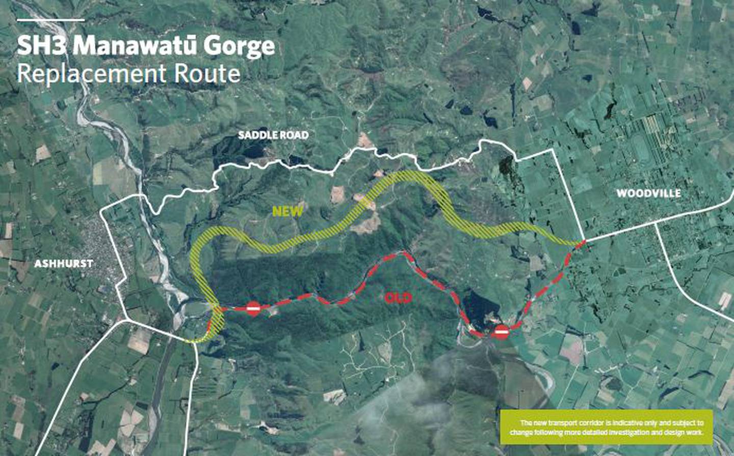
The chosen route will reconnect the Manawatu, Tararua District, Hawke's Bay and northern Wairarapa regions - but bypass the township of Ashhurst.
The preferred option selected was number three of the four shortlisted options.
The route runs from near the Te Apiti carpark western entry of the closed Manawatu Gorge, across the Ruahine Ranges north of the Gorge, before emerging at Woodville.
NZTA spokesperson Emma Speight said Option 3 emerged after a thorough investigation and extensive consultation as the safest and most resilient route which best balanced the combined needs of the communities, businesses and road users who would use it.

"It will re-establish a key strategic transport and freight link that supports the needs of the people and economies of central New Zealand," Speight said.
"Alongside this, the Transport Agency has committed to advancing investigations for a Regional Freight Ring Road, including a second road bridge across the Manawatu River, which stakeholders across the region see as a critical package to unlocking regional economic development opportunities."
The Detailed Business Case process would begin immediately, covering a 10 year programme of work, targeted for completion at the same time of the replacement route for the Manawatu Gorge.
Horizons Regional Council Chairman Bruce Gordon says that progressing a Regional Freight Ring Road in parallel with the Manawatu Gorge replacement route would be a significant step forward for the region.
"It would connect key freight hubs and bring significant improvements to freight and passenger vehicle movements through the Central North Island hub of Manawatu, improving travel times and lowering costs.
This better positions the region to attract investment in logistics, manufacturing and processing, which is critical for the region's future growth and prosperity," Mr Gordon says.
The inclusion of a second bridge over the Manawatu River would assist in building the region's resilience, provide a safer and more effective connection between some of the region's key industrial areas, and remove heavy trucks from Palmerston North's city centre.
Palmerston North City Council Mayor Grant Smith said engagement with regional stakeholders to reach a solution that achieves wider strategic objectives for both the region and the country as a whole was important.
"It is important for unlocking future regional economic development that the new State Highway 3 link offers connectivity and alignment to a proposed Regional Freight Ring Road and a new bridge. We are pleased this package of work achieves this," Smith said.
"It is a great example of central and local government collaboration to optimise public investment in infrastructure for the long term, and reflects the impact of the new Government Policy Statement on Transport, which requires regional economic development considerations to be taken into account."
A detailed business case on the new SH3 route would be finalised over the next few weeks. The project team would then seek resource consents with construction planned to begin in 2020, with the new road completed by 2024.
- Option 3 will have an average incline gradient of 5.8%, with a maximum of 8% (in comparison, the current main alternative route, the Saddle Road, has a maximum gradient of 16%).
Travel time is estimated to be 13 minutes for general traffic (compared to an average 16.7 minutes that it took to travel the Manawatu Gorge).


