Otago has again shown its winters are something to be envied, with the region having one of its driest on record.
Dunedin had the driest winter of the country's six main centres and its third-driest on record, while Alexandra had its driest winter in nearly 30 years, the National Institute of Water and Atmospheric Research (Niwa) winter 2011 report shows.
Niwa climate scientist Georgina Griffiths said winter arrived late this year. June was the third- warmest on record, characterised by frequent northeasterly winds.
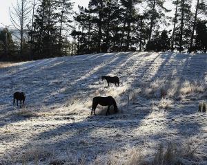
Temperatures remained high through a "stormy, unsettled and extremely windy July", until a polar blast hit on July 24-26, bringing a bitterly cold air mass over the country and snow to the lower South Island, including Dunedin and Queenstown, closing roads, airports and schools, stranding motorists and disrupting businesses.
August was similar until a second polar blast hit on August 14-17, bringing snow to the South - again bringing much of Otago to a standstill - and also to the North Island.
Overall, the winter was relatively dry, particularly for the South Island where rainfall was well below normal for parts of Otago.
Alexandra recorded only 30mm - 39% of its normal rainfall - its lowest since 1983.
In Dunedin, only 84mm fell - 41% of its normal rainfall - and its third lowest since records began in 1918. In comparison, 133mm fell in Christchurch, 356mm in Wellington and 310mm in Auckland.
Winter mean temperatures were well above average (more than 1.2degC above) across Central Otago and the lakes district.
However, it was Dunedin which recorded its third-highest mean maximum winter air temperature of 11.4degC, 1degC higher than normal, and its second-highest daily minimum temperature of 12.2degC on June 1.
The city's mean winter temperature was 7.6degC, 1degC higher than Christchurch's, but lower than Wellington's 9.4degC and Auckland's 12.1degC.
In contrast, below-average temperatures were recorded in inland North Otago, while Queenstown recorded its fourth-lowest minimum with -8.9degC on July 26.
Balclutha stood out for its sunshine, recording 382 sunshine hours, 131% of normal and the fourth-highest recorded since 1964.
It also recorded its equal second-highest minimum temperature of 9.4degC on June 1. Dunedin also recorded well above normal sunshine hours of 386 - 63 hours more than Wellington and only seven hours less than Auckland.
Niwa's seasonal climate outlook for spring predicted warmer than normal temperatures were to continue in Otago.
Rainfall, soil moisture levels and river flows as a whole were likely to be about normal for the region.
Dr James Renwick said while the tropical Pacific remained in a neutral state, there was a possibility of a resurgence of La Nina conditions, at least temporarily. However, many models indicated the neutral state would continue for spring as a whole, he said.