A windy surge is heading towards the country today and weather experts warn it will only be the start of a wintry blast that will make for a wet, windy and cold weekend.
It will hit the South Island today before breaking up over the North Island tonight and tomorrow.
On Sunday, a cold front is forecast to move northeast across New Zealand, followed by a strong disturbed southwest flow, bring snow to 200m for much of the southern region.
A MetService spokesman said there was "moderate confidence" of heavy snow falling above 200m in Fiordland, Southland and Clutha during Sunday.
The area covered by the severe weather outlook did not include Dunedin, but the MetService was predicting snow flurries to 300m in the city on Sunday.
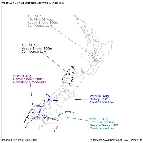
There was also a possibility of severe southwest gales in exposed parts of coastal Southland, Clutha and Dunedin on Monday and early Tuesday.
Meanwhile, Civil Defence says it is expecting potentially hazardous king tides and high seas on the West Coast from today until next Tuesday.
WeatherWatch says a Southern Ocean storm is "pouncing'' on the area - bringing waves of up to 15m high to the south west, as well as heavy snow, hail, isolated thunder and severe gales.
"The rough West Coast lives up to its name with highly dangerous beach and marine conditions across the next 72 hours at least,'' a statement said just before 8.30am.
MetService has warned an active cold front is forecast to move quickly eastwards across the country this morning, and an associated deep low will also move eastwards to the south of the South Island during the day.

Strong wind warnings were now in force across the South, he said.
"Strong wind gusts could damage trees, powerlines and unsecured structures. Driving may be hazardous, especially for high-sided vehicles and motorcycles."
The Queenstown Lakes District Council warned severe wind gusts were forecast for the area, with up to 120kmh from 9am today.
Meanwhile, farmers in the lower part of the South Island are being warned that wind chills over the next few days will be "brutal'' in Southland, Otago and parts of the West Coast.
WeatherWatch head analyst Philip Duncan said: "The wind chill will be significant on Friday in the lower South Island. If you have newborn lambs and calves, just be aware this is going to be a brutal wind chill for you - well below zero, minus fours, minus fives as we head into Friday night."
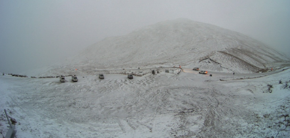
A period of heavy snow was expected above 500m in Fiordland this morning and would continue until 11pm. Heavy snow was also forecast for southern parts of Central Otago and the Southern Lakes, between 2pm and 11pm today.
"Snow accumulations may approach warning amounts above 700m," MetService said. "The strong wind warning for severe gale southwesterlies in effect for this area could cause snow drifts."
The Milford Road (SH94) was closed on Thursday afternoon and would remain shut from Knobs Flat to Chasm Carpark until Saturday.
The Milford Road Alliance advised that heavy snow is widespread and causing tree-falls. More delays and closures are possible throughout the weekend, with continued snow forecast.
Heavy rain is also affecting the South as surface flooding has started to accumulate in Bluff causing speeds on SH1 near the intersection with Nichol Rd to be temporarily reduced to 30kmh.
Caution is also advised on SH8 from Roxburgh to Raes Junction due to surface flooding.
SNOWY ROADS
Alpine passes and other high roads will be affected by snow on Friday, the New Zealand Transport Agency advises.
CROWN RANGE ROAD
Light snow has been falling over the summit of the Crown Range this morning. Snow was expected to affect the Crown Range Road between 2am and 11pm today, with 10cm to 15cm expected to settle on the road above 700 metres, with lesser amounts down to 500 metres. Further snow showers are possible on Saturday evening.
MILFORD ROAD (SH94)
The road is closed. Snow is expected to affect the road until early this afternoon. Until 2pm, expect 8cm to 10cm of snow to settle on the road above 700 metres, with lesser amounts down to 500 metres. A few snow showers are expected to return early on Saturday morning. Between 4am and 9am, expect 2cm to 3cm of snow to settle near the summit of the road.
LINDIS PASS (SH8)
Until 11pm, 4cm to 8cm of snow may settle on the road above 700 metres, with lesser amounts down to 500 metres. Further snow showers possible on Saturday evening.
Meanwhile, the NZTA has issued a caution for black ice on SH8 between Milton and Raes Junction.
LEWIS PASS (SH7)
Until midnight, expect 15cm to 20cm of snow to settle near the summit of the road, with lesser amounts down to 600 metres.
ARTHURS PASS (SH73)
Until 10pm, 3 to 6cm of snow may settle near the summit of the road, with lesser amounts down to 600 metres.
HEAVY RAIN
Heavy rain was expected below 500m in Southland and Clutha, between 11am and 11pm, a MetService spokesman said.
"Rain is expected with some heavy falls during this time, and rainfall accumulations may approach warnings amounts."
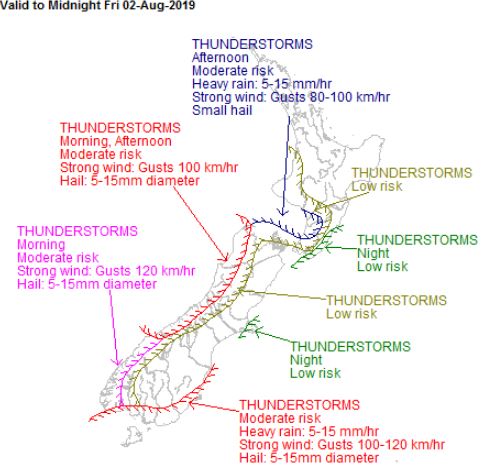
In Dunedin, today's forecast was for southerly wind gusts up to 90kmh and periods of rain in the afternoon, bringing possible thunderstorms and hail and a high of 10degC, he said.
Oamaru was expected to get rain with possible thunderstorms and hail and strong winds up to 110kmh and a high of 12degC.
Heavy rain was forecast to hit Queenstown, while Wanaka and Alexandra would also be wet. The forecast high for the area was 9degC.
Thunderstorms and hail were also likely for Invercargill and a high of 10degC, he said.
"People are advised to keep up-to-date with the latest warnings and watches in case any changes are made, or other areas are added."
- By John Lewis, ODT Online, NZME and RNZ