
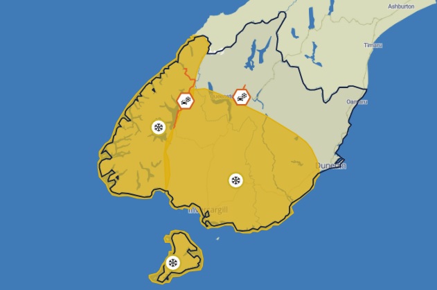
MetService today issued heavy snow watches for Otago south of Queenstown, Alexandra and Mosgiel, including Southland and Stewart Island from 3pm on Saturday until 9pm on Sunday.
There was also a chance of gale-force winds about the eastern coast of Otago and Southland over the weekend.
The forecaster said snow was expected to about 100 metres, with heavy falls possible above about 300 metres.
A 45-hour heavy snow watch has also been issued for Fiordland from 9pm on Friday.
Road snowfall warnings were earlier issued for the Milford Road (State Highway 94) and Crown Range, but these were lifted about 8.45pm on Thursday.
However, a brief period of snow was likely above 300 metres on the Milford Rd from Friday night into early Saturday, and more snow was likely later on Saturday.
MetService meteorologist John Law earlier said a "swing around to southerly winds" was on its way, bringing snow and freezing temperatures.
"In Queenstown, highs will be back into single figures, sevens and eights [degrees C] as we move towards the weekend, and night-time lows of freezing to minus two degrees," Mr Law said.
Other southern centres, including Dunedin, also look set for single-digit highs over the weekend but the city should remain above zero, while inland areas are tipped to go into the minuses overnight from Friday through to Sunday.


