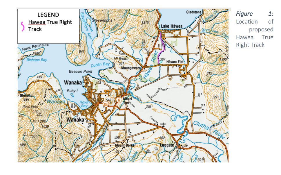
The consent application is for a new 4.5km track on the true right bank of the Hawea River, connecting to the existing Hawea River Track on the true left bank.
Queenstown Lakes District Council planner Rebecca Holden is vetting the application, lodged by the trust on February 11.

"The new Hawea River Track is planned to start at the Hawea Dam and lead, initially, as far as Camphill Rd. The idea is it will be a single track, fairly narrow in style, similar to the Newcastle Track; the idea being we are providing different quality of tracks for different users," Mr Wellington said.
A survey of track users over summer had provided feedback that the new Hawea River Track should be kept as natural as possible, using existing tracks and tweaking them.
Users also wanted it to be accessible for adaptive bikes and strollers, while keeping the track simple, he said.
Other feedback was that the trust should upgrade a particularly rough section of the existing Hawea River Track between Camphill Bridge and the Butterfields wetland, so it was fit for purpose for commuters. That section is through a copse of trees, near where the Hawea Flat link track links to the river track.
The new track on the true right of the river runs from the end of a four-wheel-drive track on Contact Energy Ltd land, along a marginal strip to the ‘wave’ car park on Camphill Road.
There will be some minor vegetation clearance and smoothing out of undulations.
The Department of Conservation, Contact Energy and the Hawea Golf Course have given affected party consent, while Aukaha, on behalf of iwi, was working towards affected party consent.
The land has a general rural zoning with a Wāhi Tūpuna overlay — meaning it is a site of significance to Maori.
Conditions for building the track include obtaining a small right of way easement over golf course land and a lizard management plan.
Mr Wellington said other projects in the pipeline included:
- The official opening of an extension to a Makarora nature walk through QEII covenanted private land in March. This has already been built and signs are due to go up soon.
- Building a track from Hook Restaurant under the Cardrona Valley Bridge on State Hwy 6 to join an existing 4WD track to Ballantyne Rd. This will also serve as a link to the future Great Ride linking Wanaka and Cromwell. Easements are in place and the trust will seek resource consent and Doc approval.
- Building a track through Peninsula Bay, around the base of Sticky Forest, linking up with the lakefront track. Resource consent would be lodged soon. The track has been designed but is not funded.
- Investigating a walking track around Rocky Hill, near Diamond Lake.
- Continuing to work on the proposed Great Ride to Cromwell. Mr Wellington said "this will be the last cab off the rank".
- Updating the tracks trust website and setting up a Friends of the Upper Clutha Tracks Trust.
New trustees who recently joined are Mark Price, Jeremy Martin and David Lindsay.