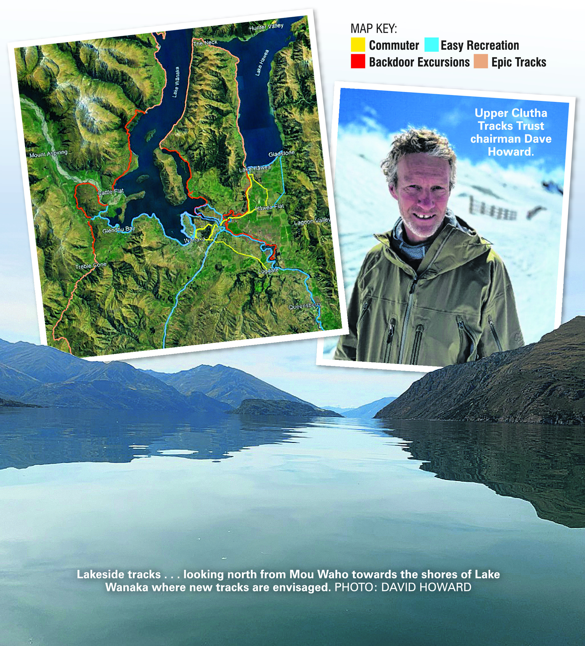
The track would traverse the precipitous East Wānaka faces between Wānaka, "the Neck" and Hāwea.
While it is no more than an orange line on a map at present, and labelled "long-term aspirational", trust chairman Dave Howard believes the track proposal demonstrates what "could be possible and be of high value to the region".
"Imagine a multi-day hut-to-hut trip around Lake Wānaka.
"It is a great thing to do in the school holidays and it could become a rite-of-passage for local kids, like hiking the Treble Cone summit for the first time.
"The track would serve multiple users, whether it’s a short stroll along the lake or a quick marathon in the rain before breakfast (you know the type).
"Everything starts with some crazy concept.
"Within the next two years, we can bike 300km (off-road) from Wānaka and Queenstown to Dunedin, so the 80km Lake Wānaka/Hāwea loop is entirely achievable.
"This particular concept has all the elements to make it one of New Zealand’s iconic tracks.
"But most importantly, it’s for local residents to enjoy accessing the outdoors and engaging with nature as part of everyday life," Mr Howard said.
The track-building veteran is well aware of the amount of work required before work begins on any new track.
Even more crucial and difficult than raising money is negotiating access.
The new tracks in the strategic plan would require access to Department of Conservation and private land, and that had not yet been secured.
"The typical response from future users is ‘wow, that would be amazing’.
"The reality is that the track has to work for everyone, particularly the landowners.
"We work hard to create benefits for landowners and mitigate any potential down side through careful planning and track design.
"Every landowner has their own specific interests and we must invest in the time to understand these.
"We have had great success with developing ecological restoration sites right through to creating new business opportunities for landowners."
Another "aspirational" project in the strategic plan is extending the Minaret Burn track, which begins at the mouth of the Matukituki River on the west side of Lake Wānaka.
"This route has a few challenges with the long distance, isolation and connection to Makarora.
"A successful long-term concept to make this track viable would likely include multi-day trips, boat transfers, mixed adventures of bike/boat/walk.
"It is the sort of track that would evolve over time and requires several businesses to offer services to track users."
The strategic plan is intended to be a 50-year vision of what could be possible and acknowledges the trust is "heavily reliant on the good will and collaboration of landowners".
The charitable trust, founded in 2006, is run by volunteers and has spent $2.4million on its 95km track network.
Tracks were not only a valuable recreational resource for residents but also brought economic benefits, he said.
"Businesses benefit by providing services to track users — from accommodation, hospitality, shuttle and rental and more.
"The New Zealand Cycle Trail impact assessment [2021] shows that track users stay longer and spend more than the average visitor.
"The 23 Great Ride trails returned $950m of direct economic benefit to their communities in 2021.
"Our future trail network would return tens of millions dollars to our community annually."
The trust’s more immediate plans are for improvements to the connection between Wānaka and Hāwea, by upgrading the commuter route and building a new trail on the true right bank of the Hāwea River, about which Mr Howard expects to announce more detail soon.
The strategic plan, including a map showing the existing and proposed tracks, is available on the trust’s website at uppercluthatrackstrust.org.nz