The Otago Regional Council (ORC) and the Clutha District Council (CDC) launched their draft Milton 2060 flood risk management strategy this week.
It was developed from a joint working party created by the ORC and the CDC in 2007 to study flooding in the area.
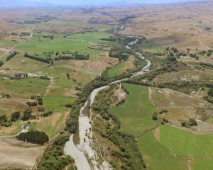
Milton has a history of flooding dating back to European settlement in the 1850s. Most recently, extensive flooding occurred in 2006, 2007 and 2010.
During flooding in late July 2007, more than 100 residential properties were affected, and about 46 people were evacuated from their homes.
Otago Regional Council environmental engineering and hazards director Dr Gavin Palmer said part of the strategy's purpose was to highlight areas where growth could be achieved without the risk from future flooding.
The strategy looks ahead to the next 50 years.
Clutha District Council planning and environment manager Murray Brass said one of the major parts of the strategy was the proposed inclusion of a range of land-use controls in the Clutha District Council's district plan to assist the sustainable growth of the area.
"We're not looking at taking anyone's existing rights away. It's only the new developments that will be affected by this," Mr Brass said.
The strategy identifies areas prone to flooding, separating them into four main areas: the Tokomairiro River floodplain, low-lying ponding areas, Milton urban area, and rural and semi-rural areas on the Tokomairiro Plain.
The Tokomairiro River floodplain can be covered by up to 2m of water during flooding, usually lasting 24-36 hours.
The strategy suggests creating more defined escape pathways to control activities which could restrict safe access during floods, and advises particular roads to be managed by the relevant roading authorities as identified as escape and access routes.
The low-lying ponding areas - urban areas where water ponds during prolonged heavy rainfall - can be covered in water to a depth of 1.5m, and were last flooded in July 2007.
Flooding in these areas can create a risk of contaminated floodwater, requiring the sealing of the wastewater collection system.
These areas also heavily rely on flood protection assets such as floodbanks and pumps.
The rest of the Milton urban area is generally covered in much less water during a flood than those listed above, varying between water depths of up to 0.3m.
The biggest flood management issues faced by this area are the disruption of transport links, and links to ponding areas or the Tokomairiro River.
The last area covers the rural and semi-rural areas on the Tokomairiro Plain, including the floodway corridors which drain water from the floodplain and eastern hill catchments.
The strategy advises avoiding additional flood risks and reducing existing flood risks through land-use controls, and ensuring there is efficient drainage.
Mr Brass said while the proposed land-use controls would place new restrictions in certain areas, which might affect property values, there was an overall benefit for most residents.
"The strategy identifies the main areas of risk and for some people it will highlight the existing risk areas.
"For others, the question of whether their properties are at risk will be removed."
Mr Brass said the strategy gave councils and Milton a way forward in the management of flood risk around the township.
The councils are seeking input from residents and landowners on the strategy before they formally reconsider the document.
Mr Brass encouraged residents to read the summary document and full draft strategy and make a submission.
Submissions to the draft strategy close at the end of next month.