A red heavy rain warning for parts of Otago has been extended until 11pm on Friday. It was earlier expected to stay in place until 9pm.
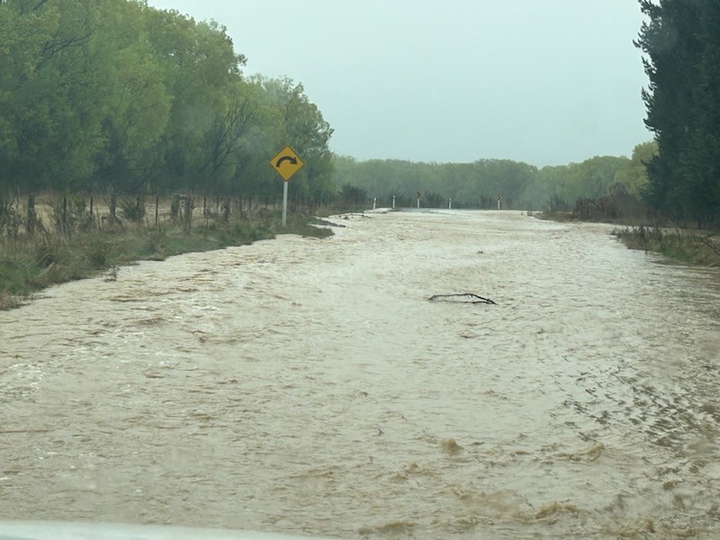
Surface flooding and a small number of slips continue to affect road networks across Otago, prompting a plea for people to stay at home unless absolutely necessary.
Group Controller for Emergency Management Otago (EMO), Matt Alley, says with further rain forecast – combined with a level of unpredictability - rivers and streams could continue to rise and potentially overflow on properties or roads.
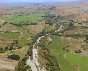
At 09.3am today, MetService said the slow moving front was expected to bring further heavy rain to the southeast of the South Island - highlighting Otago. The duration and the amounts were very unusual and major impacts were being felt in North Otago, Dunedin and coastal Clutha. A red warning remained in force for those areas but the rain was expected to ease late tonight.
Mr Alley said ORC flood and drainage infrastructure across the Taieri was working well. Flood and drainage infrastructure in the Lower Clutha was also working well but there was severe surface flooding from the rainfall.
Even for farmers who have moved stock already, Mr Alley suggested they assess their circumstances and whether stock should again be moved to higher ground - but only if safe to do so.
People can keep updated on this changing situation through Emergency Management Otago Facebook page and website, and websites and Facebook of NZ Transport Agency/Waka Kotahi, and local district and city councils.
“Unless absolutely necessary, please avoid travel in the region as many parts of Otago are still being affected by this event. Rain is predicted to continue through to this evening.
“There’s several sign-posted road closures and people should not try to go any further. More roads will likely be closed as rivers and streams rise or water run-off pools around roads. We don’t want anyone caught out by this."

Toko Mouth cut off
The small South Otago coastal settlement of Toko Mouth is cut off, without power and waterlogged on Friday.
The settlement has mostly holiday homes, however, there is a small community of permanent residents.
Resident Basil Vlachakis contacted the Otago Daily Times this morning to say that he, along with his wife and daughter live in Toko Mouth Rd, about 2km from Milton, were "completely surrounded by water" and the power's been off since 2am.
"Powernet told me this morning that their engineers can't get to the power sub unit to turn the power on as it's completely flooded, so can't give me a time when power will be back on."
Another resident, Glenda Wallace, told RNZ said the two roads into the township were impassable.
"The road that runs along the Tokomairaro River is flooded and it's flooded right up to Tokoiti. That's been impassable since yesterday.
"The coast road that goes to Kaitangata is higher and it's got flooding and a lot of damage. It probably took me an hour to come through there - about 18 kilometres - last night and now it's impassable."
While the community was without power and cut off from the rest of the Clutha district, its residents were rallying around each other, she said.
"Those houses that run along the river have got water up to the houses - the creek is running high and fast," Wallace said.
"But we live in a beautiful community. Everybody is checking in on each other, everyone is doing what they can to help."
A farmer had been out on his tractor and other residents in four-wheel drives to check on the rest of the community, she said.
They had not heard from Civil Defence, but now it was a matter of hunkering down until the roads could be reopened.
Another resident and farmer Simon Davies told RNZ there was significant flooding and the settlement has been cut off by road. Paddocks are flooded so he hoped stock got to higher ground.
Clutha
More than two dozen roads around the Clutha district are closed and even more are affected by flooding and slips.
State Highway 1, north of Milton, is closed due to flooding of the Tokomairaro River.
Clutha Mayor Bryan Cadogan told RNZ a state of emergency has not been declared yet, as officials and services are continuing to cope with demand.
The Tokomairaro River can subside as quickly as it rises but the council is keeping a close eye on it and the situation in Milton.
Sandbags have been delivered to the Milton Community Library for people to collect. For sandbags at King Engineering in Balclutha, however, people will need to bring a shovel.
- For a full list of roads affected by flooding go to the Clutha District Council's Facebook page
Many roads in the district are now closed or seriously affected on Friday due to the heavy rain and surface flooding, as well as slips, a spokeswoman for the Clutha District Council said.
She said it wasn't possible for contractors to get signage on to all roads affected, and people should stay home if possible.
"Due to the nature of this event and how widespread it is we are unable to sign out every patch of surface flooding. Our contractors are focusing on the the most dangerous areas.
"Where possible, we advise that people should stay home and not drive around taking photos. If you see a road closed sign please don’t drive past it as we don’t want people risking their own safety."
The Nuggets Rd is closed due to a slip.
Other roads affected are: Owaka Highway by Romahapa, Puaho Rd, Finlayson Rd, Akatore Rd, Moturata Rd, Summer Hill Rd, Finalyson Rd, Waihola Moturata Rd, Taieri Beach, Papatowai Highway, Tarara and Tautuku Beach.
Water wastewater teams were busy monitoring and addressing any issues affected by the heavy rainfall. "Many of our wastewater pump stations have had overflows. We advise people to stay out of floodwaters and treat as there is a chance that the water is contaminated."

Southland
Rain was forecast to continue in Southland for much of today and a watch for heavy rain is in force for the region, MetService said.
It was decided to close the Otautau Bridge in Southland as a precautionary measure from 8am and it could remain shut for 24 hours.
A spokeswoman for the Southland District Council said the river was expected to peak tonight and was likely to be at a similar level to September last year. Further rain was forecast for the day.
"Closing the bridge will mean community members won’t be able to travel over the bridge on Main Stt in Otautau in either direction.
"As river is expected to peak overnight this might mean the bridge may be closed for around 24 hours. It’s a precautionary decision, to ensure the community’s safety."
Evacuations of Otautau residents were not expected. However, the community should be prepared to stay put should further flooding affect more roads around the township.
Other roads in the area have been affected by surface flooding. "Please take extra care if travelling over the next few days and avoid driving through flooded roads."
Meanwhile, the Pyramid Bridge is also closed on the Southland district side (Riversdale-Pyramid Bridge Rd). Taramoa-West Plains Rd is closed.
Piano Flat Rd is closed at the Waikaia township turnoff.
Calder Rd and Forbes Road intersection, Lochiel, is flooded with signs up.

State Highways shut
Several closures are in place on the state highway network in Otago and Southland due to flooding, NZTA/Waka Kotahi advised this morning.
SH88 Forsyth Barr Stadium to Port Chalmers in Dunedin is closed due to a slip.
SH87 Kyeburn to Hyde remains closed due to flooding.
SH90 Waikoikoi to Tapanui is closed due to flooding. A detour in place - northbound traffic turn left onto Koi Rd, right onto Sedden Hill Rd, continue along Station Rd, left to rejoin SH90 Reverse for southbound traffic.
State Highway 1, north of Milton, closed due to flooding of the Tokomairaro River.
All other state highways remain open.
Central Otago
Continuous rain is set to fall in the region today and a spokeswoman for the district council advises people not to drive but to stay at home "especially those in and around the Maniototo area".
There are high river levels and surface flooding in and around the Manuherika and the Maniototo.
Road closures
The Kyeburn River Rd closed from White Road-Danseys Pass Rd about 10am on Friday.
The Ida Valley Omakau Road is closed at Omakau Bridge. There is a detour for light vehicles via Swindon St in Ophir. Heavy vehicles were asked to use SH85 as Delta workers are stabilising power poles at the site.
Danseys Pass Rd - closed from McCready Rd, resident access only
Boundary Rd from Auripo to Ida Valley Rd
Auripo Rd - no access from house 843 to Thurlow Rd
Kokonga Rd closed at the SH87 end
Athenaeum Rd (Between White Sow Rd and Maniototo Station Rd in Wedderburn)
Naseby Link Rd (from SH85 to Gimmerburn Rd)
Reef Road
Brindson Rd