Key points
- Northland, Auckland, Thames-Coromandel, Waikato, Hauraki, Bay of Plenty, Whakatāne, Ōpōtiki and Tairāwhiti regions have declared a state of emergency.
- Thousands of households are without power.
- Trains in Auckland have been cancelled until at least midday on Tuesday.
- Mandatory evacuations have been ordered in Whakatāne, and others in Ōpōtiki, Onepoto, Tologa Bay, Te Arai Manutukeare and other low-lying areas are being urged to find shelter.
- Air New Zealand has cancelled all domestic flights from or through Auckland, Hamilton, Tauranga and Taupo, until at least midday Tuesday. Some international flights are also either cancelled, or diverted to another NZ airport.
- Most schools in the Auckland region have closed and all non-essential services in the city, including libraries, community centres, early childhood education centres, and active recreation centres are all shut.
- The Government has unveiled a $11.5 million package to support NGOs and community groups.
- Gabrielle has been downgraded to a sub-tropical low pressure system from a Category 2 cyclone.
North Island regions have declared states of emergency, with fears that a storm surge tonight will lead to more flooding and slips, driven by relentless rain and wind whipped up by Cyclone Gabrielle.
Residents in New Zealand's largest city of Auckland and surrounding regions are being told to brace for more damaging weather as Gabrielle nears the country's coast, bringing severe winds, heavy rain and monster waves. Thousands throughout the island were without power.
Regions that have declared a state of emergency are: Northland, Auckland, Thames-Coromandel, Waikato, Hauraki, Bay of Plenty, Whakatāne, Ōpōtiki and Tairāwhiti.
Gabrielle is the second significant weather event to hit Auckland and the upper North Island in just a few weeks. Last month, Auckland and surrounding areas were hit by record rainfall that sparked floods and killed four people.
Monster waves and rising seas stirred up by the cyclone caused havoc in Coromandel and Northland earlier today and heavy rain - bringing localised slips and flooding - was likely in Auckland from this afternoon and evening, MetService warned.
A photo sent to The New Zealand Herald shows two people abandoning their cars and walking through dangerous flood waters on the road to Hahei in the Coromandel.

The national forecaster urged Aucklanders to be alert to heavy rain, flooding, and slips and for storm surges during the Tuesday's 2am high-tide in east coast areas. At an Auckland emergency response briefing, deputy controller Rachel Kelleher said: “We’re certainly not out of the woods yet”.
Coromandel officials say the region is “on one knee now” and expecting a “miserable, uncomfortable night”.
The Defence Force has located 150 staff across Auckland and neighbouring regions and is bringing in welfare supplies to civil defence centres and shelters.
Mandatory evacuations have been ordered along part of the eastern Bay of Plenty coastline, with the Defence Force helping to evacuate a campground near Ōpōtiki tonight.
As many as 400 properties were being asked to evacuate in the Ōpōtiki District between Waiotahe and East Cape, with another 100 evacuations ordered in the Whakatāne District, including at Ōhope Beach. People staying at the Tirohanga Campground are being moved to Ōpōtiki College.
Ōpōtiki District Council incident controller Gerard McCormack told RNZ the worst of the cyclone was due to hit at about the same time as high tide, which could cause serious inundation in the middle of the night.
Te Araroa Civil Defencehas advised residents of Onepoto in the Gisborne region to evacuate and residents in Hikuwai Tolaga Bay and Te Arai Manutuke have also been advised to evacuate with police and Fire and Emergency crews assisting.
Further north in Whangārei, those in the city centre have been told to evacuate as flooding hits.

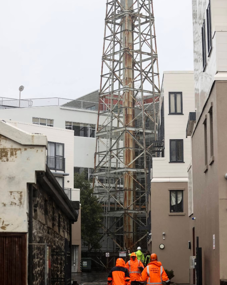
Apartments evacuated amid tower fears
Fifty apartments in central Auckland have been evacuated tonight after fears a 109-year-old steel tower in the suburb of Mount Eden could collapse.
Auckland Emergency Management has established a temporary exclusion zone around the Colonial Ammunition Company Shot Tower.
Controller Mace Ward said the forecast high winds and weather conditions associated with the cyclone could cause the 109-year-old and approximately 30-metre-high tower to collapse, damaging the surrounding buildings.
Residents across other Auckland suburbs have also been evacuated as Cyclone Gabrielle bears down on the upper North Island. Multiple homes are being evacuated in Birkenhead on the North Shore due to falling trees.
Thousands without power
Worsening weather conditions have brought a rise in power outages across the Auckland region and thousands of households in Northland hunker down for a night without electricity, RNZ reported.
Vector said that as of 6pm, 22,000 customers were without power - compared to 13,000 earlier in the day. It said crews continued to work in "terrible conditions" but nightfall would make restoring power more difficult and some outages would not be safe to work on.
Further north, Northpower reported that more than 15,000 households and businesses were without power. Far North lines company Top Energy said about 5500 customers did not have electricity, down from 14,000 at 4am today.
In the south, Wellington Electricity was warning of power outages throughout the region tonight as Cyclone Gabrielle made its way down the country.
Extra funding announced
Prime Minister Chris Hipkins today announced this afternoon the Government would unlock an extra $11 million for funding to support flood and cyclone-hit regions and communities.
“We just have to be ready ... the worst is yet to come.”
The money comes in the form of a Community Support package - and aims to help tens of thousands of people affected. Some $4 million is to ensure community organisations and iwi can support well-being, with another $4 million specifically for a Care in the Community programme, $1 million is for replenishing foodbank stocks and the rest will go towards various rapid response programmes.
Hipkins said the package had been reallocated from underspent Covid-19 funding. He said Cabinet was due to discuss further financial support for Auckland and other flood-struck areas on Wednesday but that was brought forward due to the impact of the the cyclone.
MetService forecaster Georgina Griffiths said mid-afternoon that Auckland was seeing a pause in winds whipped up by Gabrielle - but rain was on the way.
Localised impacts, such as flooding and slips, were likely, she said. But not everyone would see the heavy rain. Residents were about halfway through the cyclone impacts - with better weather forecast from Wednesday, she said.
Parts of Auckland that had not yet seen challenging wind conditions were likely to see them tomorrow and Great Barrier Island - which was very close to the cyclone - was in for a “hard night”.
Griffiths said the central pressures of Gabrielle were very low and did “pack a punch”.
A 2am high tide in Auckland could bring about half a metre storm surge on the east coastline of the city. There would be extremely large waves of 5 metres to 8 metres coming in, she said.
The wind was the “top problem”, causing a lot of outages. Gusts reached 160km/h at Great Barrier Island.
The rain this morning had saturated the ground and once the heavy rain kicked in this morning, meaning some areas could expect localised slips and flooding.
Auckland Mayor Wayne Brown said just after 2pm that the next 24 hours will be challenging for all Aucklanders and urged people to continue to keep an eye on those around them.
The military was responding to those who needed help and support. Brown asked those who needed help to be patient as they were at full capacity.

The cyclone's weather system was expected to re-curve towards Great Barrier Island this evening.
“We are not through the worst of it yet,” Ball said.
WeatherWatch says Cyclone Gabrielle’s air pressure is expected to drop in the next 24 hours, making the storm more intense, and the lowest air pressure from the storm was expected before dawn on Tuesday. On its website, it said in simple terms, the lower the air pressure the more powerful and severe the storm would be.
“It makes the storm more unstable and will see wind and rain spread further out. The fact this intensification is going to occur as Gabrielle approaches the Auckland and Coromandel Peninsula regions makes it more problematic and complicated.”
Prime Minister Chris Hipkins chaired Cabinet virtually today - he travelled to Auckland yesterday and the cancellation of almost all flights has meant he cannot return to Wellington.
That could also have an impact on the opening of Parliament tomorrow, when Hipkins is due to deliver the Prime Minister's statement setting out his plans for the year. The flight cancellations around much of the North Island will make it difficult for a lot of MPs to get to Wellington.

Transport disrupted
Auckland Transport warned of “significant disruptions” to Auckland’s transport network.
“KiwiRail, the track owner, has suspended all passenger train services in Auckland from 8pm tonight (Sunday) - for Britomart inbound services and 9pm for Britomart outbound services - to at least 3pm on Monday to protect passengers and train crews.
“Due to this late notice, rail replacement buses are not available tomorrow other than those already in place on the Onehunga Line and Southern Line between Otahuhu and Newmarket. People who need to travel will need to use AT’s regular scheduled bus services."
Auckland Transport will continue working to source some buses for rail replacement services for tomorrow.
Interisland ferries traversing Cook Strait have been cancelled for 24 hours from 2am tomorrow in light of heavy rain and wind warnings.
Meanwhile, Air New Zealand said it would resume flying from Tuesday, having cancelled 509 flights due to the cyclone. It is adding 11 extra domestic flights to its schedule to help with the recovery efforts.

Authorities have warned people to stay off of roads, prepare for their communities to be cut off by slips and downed trees, and for widespread power cuts across the upper North Island.
Last night as the Auckland Harbour Bridge remained closed and 25,000 homes across Northland, Auckland and Coromandel were without power, one lines company told customers to be prepared for prolonged outages in the days ahead. “Some properties may be without power for days if damage is severe,” Counties Energy said.
Many schools across Auckland and Northland will remain closed today, based on Ministry of Education advice. The decision has been left to each educational institution and schools were told to communicate closures directly to students and parents.
Aucklanders have been advised to work from home if possible.
'Critical day'
Cyclone Gabrielle is bringing a "dangerous combination of high winds and heavy rain" today, Minister for Emergency Management Kieran McAnulty said.
"MetService has advised me that today is the critical day in the event. Please keep up to date with MetService for weather warnings, and your local Civil Defence Emergency Management group for local updates."
The need to declare a national state of emergency was being monitored and actively reviewed every four hours, he said.
"We have not reached that point and we may not have to. This is an all of government response with all agencies ready to respond as needed."
McAnulty said the key question at this point guiding the decision to announce a national state of emergency is whether local civil defence agencies are able to respond to their local needs.
"We would take advice from them as to how they're coping."
There had only been two national states of emergency in New Zealand's history - the Christchurch earthquake in 2011 and Covid-19 pandemic, which began in 2020.
McAnulty said the two large events were stretching the emergency and recovery response system. "A lot of people are feeling, I think, tired, stressed about what's going on."
- NZ Herald, RNZ and Reuters


