
Heavy rain is causing havoc in Auckland and Northland as more warnings are issued and people are being warned to prepare for evacuations.
Auckland Mayor Wayne Brown has confirmed to RNZ that he has declared a state of emergency and has delegated powers to his deputy, Desley Simpson.
Brown is in Sydney on vacation but will cut short the trip and return to the region tonight.
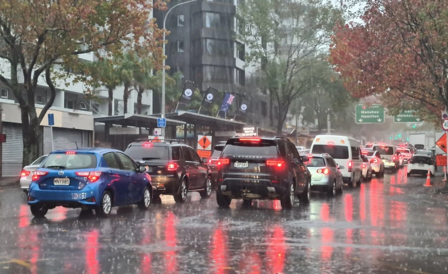
Driving conditions are treacherous with multiple closures across the motorway network.
Prime Minister Chris Hipkins said it was “a serious situation” in Auckland. Waka Kotahi were regularly updating travel information and people should check before travelling.
MetService meteorologist Georgina Griffiths this afternoon said some regions had seen torrential rain, as much as 40 to 50mm in one hour. She said more downpours were on the way.
"Nearly out of the woods Auckland, let's get through to 7pm," Griffiths said.
Streams and rivers have burst their banks in parts of the region and schools and daycares across Auckland have evacuated. State Highway 1 at Dome Valley and the Brynderwyn Hills are closed due to flooding, Waka Kotahi says.
Auckland Transport says surface flooding is widespread in parts of West Auckland and is urging people to stay clear of floodwaters.
An emergency alert was sent out earlier: "Heavy rain and thunderstorms are affecting the Auckland region and expected to continue into the evening, potentially through to midnight tonight," it said.
It warned to call 111 if life or property was at risk, and to seek shelter with friends and family if you needed to evacuate.
Brown said the lessons learned in the Auckland Anniversary floods were behind today's declaration of a "precautionary state of local emergency".
Brown's initial slow response was widely criticised following February's floods, which left four people dead.
"While I am assured that emergency services are coping with the volume of callouts at the moment, and that they do not require emergency powers, I consider it is necessary to communicate to the public that this is something to take seriously."
Rain warnings
Heavy rain warnings are in place for Northland, Auckland, Coromandel Peninsula, Bay of Plenty including Rotorua and in the South Island for Nelson/Tasman south of Motueka, Marlborough about and north of Awatere Valley and the Grey and Westland districts from Fox Glacier township northward.
Nelson Tasman Civil Defence says Golden Bay has seen the most rainfall over the last 24 hours.
Rivers are slowly rising and expected to peak around 3pm.
In Nelson, the Maitai River is expected to peak later this evening, at a lower level than it reached in the weekend.
Civil Defence says the rivers across the region are expected to peak at annual flood levels or lower, but this could change if there are localised downpours.
The risk of slips remains in areas with steep hillsides, and this is being closely monitored.
Authorities earlier said people needed to be prepared for significant rain today. Up to 70mm over 12 hours is expected in Auckland, while parts of the South Island could see 350mm.
Severe thunderstorms bringing torrential rain - “and a slight chance of a damaging tornado” - were likely for Northland and Auckland from 2pm today, MetService said.
MetService issued a tranche of orange heavy rain warnings and watches across the country - in Northland from 7am today to 7pm and Auckland, Coromandel and Great Barrier Island from midday to midnight today.
Already sodden Nelson-Tasman was placed under a fresh warning of 130mm possible between 6am today until 11pm. Marlborough could see 100mm in 9 hours until 4pm.
The South Island’s Grey and Westland districts could see upwards of 350mm in the 36 hours until 9pm today and Fiordland north of Doubtful Sound could get 160mm in 24 hours until 1pm. Orange heavy rain warnings are in place.
The Civil Defence’s National Emergency Management Agency (NEMA) encouraged people to prepare for the deluge over the next two days, especially for areas already sodden by a wet week.
Auckland Emergency Management, the city’s Civil Defence group, said: “Now is the time to make sure your bad weather plan is up to date.”
“Heavy rain may cause streams and rivers to rise rapidly. Surface flooding and slips are also possible and driving conditions may be dangerous,” MetService said.
A heavy rain warning is also in place about Mt Taranaki from 9am to 9pm, where 100mm could fall in.
A heavy rain watch, where rainfall amounts could reach warning levels, was issued in Bay of Plenty and Rotorua, north Taranaki, Buller, and the headwaters of the Otago Lakes - all to lapse by 9pm today.
‘We are in this together’: Authorities prepare for more rain
NEMA Director John Price earlier warned people to take care, be prepared and avoid unnecessary travel.
“Given the amount of rain that has already fallen we want people to be aware that there is an increased possibility that there could be landslides,” Price said.
“If you are driving be alert to areas of collapsed roading or slips of mud and rocks.”
The National Coordination Centre (NCC) has been partially activated by NEMA to assist response organisations and Civil Defence Emergency Management (CDEM) Groups around the nation in their reaction.
“This is a widespread heavy rain event, and NEMA is engaging with CDEM Groups to ensure they have the resources they need,” Price said.
“The Government stands ready to help the affected regions, some of which were badly hit during recent severe weather events in various parts of New Zealand
“We are in this together so check on your neighbours, friends and whānau.”
West Coast Emergency Management (WCEM) said people should delay any non-essential travel across Westland as rain batters the region.
‘Another burst of heavy rain’ and snow follows stormy weak
MetService meteorologist Andrew James said the rain band which poured on Westland yesterday would start to move eastwards today.
“That front crosses Aotearoa once more [and] moves over the country, going back to the east, bringing another burst of heavy rain to those already sodden northern and western areas.
“All of those areas that have already had significant rainfall [are] in the line for some more.”
MetService has also issued a road snowfall warning for the Crown Range Rd from 10pm today through to 5am Wednesday.
As the rain leaves mid-week, so will the warm air with temperatures expected to drop for the entire country and snow expected in the South Island.
James said the cold air will be coming up on Thursday from Antarctica.
“From Wednesday people will notice a decent drop in the temperatures, some strong winds with that system and possibly looking like a bit of snow down south too.”
By the end of the week, Auckland is in store for lows between 7C and 9C and highs of 14C and 17C.
- additional reporting RNZ


