
The Ashburton District Council made the announcement about 8.40pm.
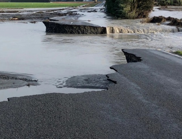
The town had been cut off to the south after the Ashburton River bridge on State Highway 1 developed a slump and was closed this morning.
- See road closures around Ashburton
- Lines closed: Rail network battered
- Big clean-up job lies ahead: PM
- State of emergency, $500k for farmers, growers
The council said through the day it had hoped an alternative route would be opened tonight.
This evening it said it "we have established an alternate route detouring around the closed Ashburton Bridge".
"Civil Defence and contractors have been working hard all day to re-establish safe access. Road conditions are variable therefore we recommend all motorists reduce speed to 60 kilometres per hour. Care needs to be taken as there are several single-lane bridges on the route."
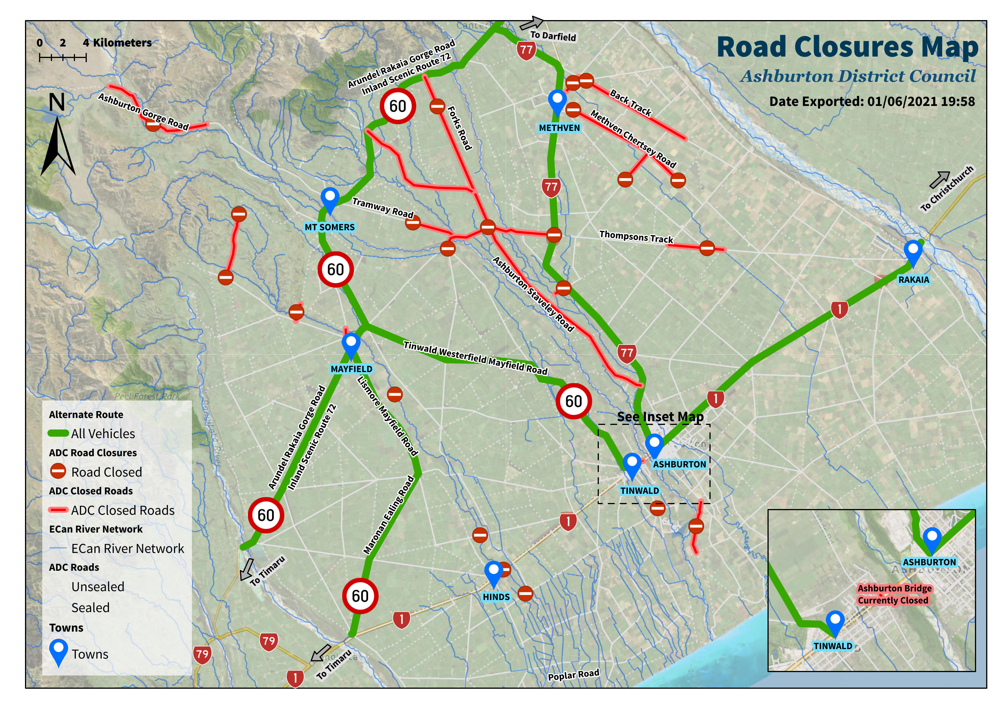
Transitioning through the district use the Inland Scenic Route 72 and follow signs
To travel north or south from Tinwald use the Tinwald Westerfield Mayfield Road to connect to the Inland Scenic Route 72
To travel north or south from Ashburton (north of the Ashburton River), use State Highway 77 to Methven and then connect with the Inland Scenic Route 72
For residents needing to cross the bridge (Ashburton - Tinwald or Tinwald - Ashburton), the alternate route is State Highway 77, Inland Scenic Route 72 and Tinwald Westerfield Mayfield Road (or vice versa). This will take over an hour so please check your fuel levels before travelling
Bridge testing
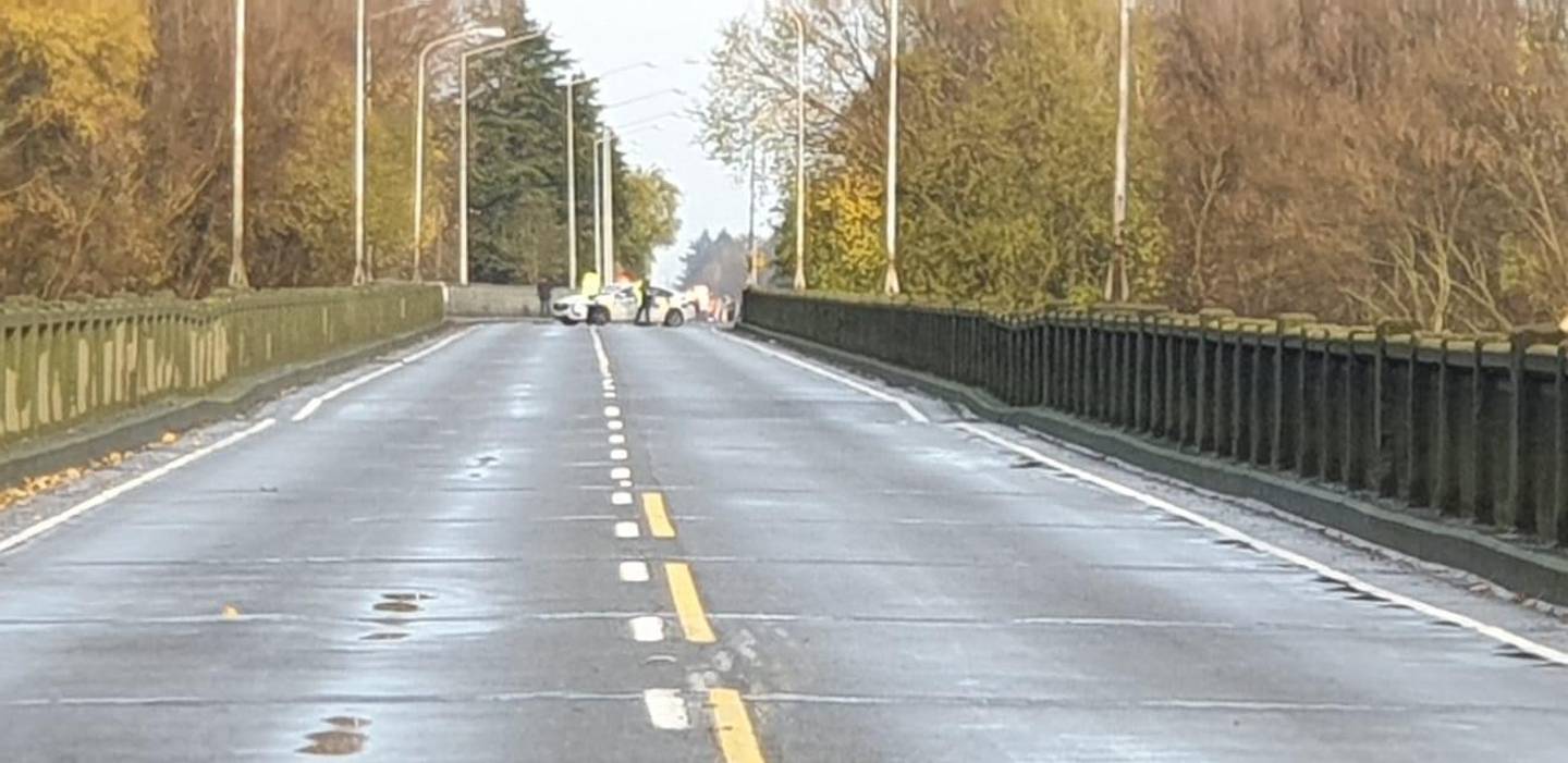
A spokesman for the council earlier said they had assessed the bridge this morning and it "would not be a band-aid type fix".
He said the bridge had sustained significant damage. A decision was made this morning to close the bridge, at the southern end of the town.
This afternoon it was announced that engineers were planning to load-test the bridge to determine the extent of damage.
Ashburton Mayor Neil Brown said engineers had examined the section where it is slumping and planned to test the integrity of the piles by placing heavy concrete blocks on to it and monitoring the result.
If there was no further slumping, the bridge could be open one way to light traffic by tonight, he said this afternoon. However, he later told RNZ's Checkpoint it could open by tomorrow.
If it sank more, the piers would need to be underpinned or replaced and the bridge would be closed for many more days or even weeks.
Stuff this evening reported that Waka Kotahi said while they had hoped to reopen the bridge to light vehicles tonight, testing was continuing and was unlikely to be finished before midnight.
Mr Brown said an experienced engineer who had made the inspection was optimistic the bridge would not move further.
The mayor flew with Prime Minister Jacinda Ardern and other MPs over his flood-damaged district today and he said the extent of the damage was overwhelming, especially in the Greenstreet area. Some farms still had water running through them.
Ms Ardern came armed with morning tea for those working from the emergency operations centre today, where she was met by Rangitata MP Jo Luxton. Mrs Luxton had been caught at Hinds by the flooding, with the bare essential in her wardrobe.
Some parts of the foothills had up to 300mm of rain since Saturday, causing the Ashburton and Hinds Rivers to flood.
Flood protection stopbanks kept Ashburton town dry, but the amount of water in the Ashburton River has compromised the bridge.
Many people in the town were caught by the sudden closure just before 7am today. One man crossed the bridge from Tinwald to swim at the EA Networks Centre and found himself spending the day at a friend’s house, while others went to work early and found their return route closed.
Tinwald Supervalue owner Gaylene Thompson said the small supermarket had been much busier than usual and run out of some items. She was working with their head office, suppliers and Civil Defence to ensure more supplies were coming.
There was no need to panic buy.
Contractors were also working on restoring Thompsons Track, which will form part of an alternative inland route while the Ashburton bridge was being repaired.
"We've been up there on Thompsons Track, contractors up there believe they might have an access way open by tonight," Mr Brown said.
"They're working as hard as they can."
An Ashburton District Council spokesman told The New Zealand Herald that engineers were on-site this morning to assess the damage.
"They have found it is not going to be a band-aid-type fix, it is going to take several days."
Meanwhile, KiwiRail has carried out initial inspections of its South Island tracks affected by flooding and there will be a delay in the re-opening of some lines.
General Manager South Island Operations Mark Heissenbuttel said there had been washouts and some damage to bridges on the Main South Line between Rolleston and Washdyke, just north of Timaru, and washouts on the Midland Line from Christchurch to the West Coast between Rolleston and Arthur’s Pass.
The affected area of the Main South Line was expected to be closed until at least Sunday, while the affected area of the Midland line will be shut for at least three days.
The Main North Line, which links Picton and Christchurch, has reopened.
- by NZ Herald and Linda Clarke


