
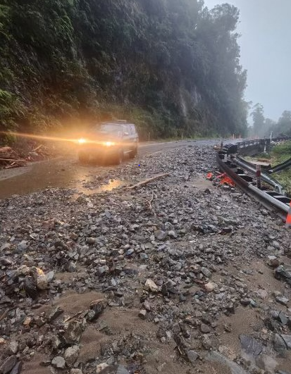
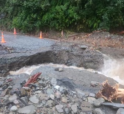
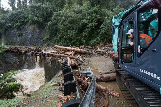
NZ Transport Agency Waka Kotahi said the washout was at Smithy's Creek, on State Highway 6 between Franz Josef and Fox Glacier.
“Creek flows have breached the southern approach at the Smithy’s Creek box culvert overnight Wednesday with the continuous heavy rain. Rain is forecast to continue all day today with periods of intense showers overnight again Thursday night,” NZTA's Moira Whinham said.
“While the rain continues to fall, crews are limited to minimising further damage and a full assessment of the damage at Smithy’s Creek will occur tomorrow morning."
Rain was forecast to ease over the weekend and crews were on standby to start repairs as soon as conditions were safe for them to do so, Whinham said.
As heavy rain and high winds are forecast to continue, the highway will remain closed today and overnight, NZTA says.
The closures either side of Fox Glacier means the township is cut off from vehicle access.
A business owner in Fox Glacier says tourists have mostly cleared out of the township.
Cafe Nevé manager Francois Goosen said most tourists got out when the road reopened yesterday afternoon.
He said locals were not very worried.
"We get a lot of rain and slips are pretty common.
"We've got extra resources and emergency services here so we're well prepared."
MetService earlier said up to 450mm of rain hit Westland on Wednesday and another 350mm was forecast by 9pm today.
As the deluge continues on the Coast, weather warnings have been issued for much of the North Island as well.
MetService this morning issued a slew of weather advisories, covering most of the South Island and much of the upper North Island.
They include heavy rain warnings for Fiordland, Southland and the Otago Lakes headwaters, and road snow warnings for the Crown Range Road and the Milford Road (State Highway 94) overnight into Friday.
Westland Mayor Helen Lash this morning said rivers were rising in the area, as the rain continued to fall.
"Rivers are on the rise, but the rain's getting more settled and consistent, so it's really what's going to be coming through these next hours is what we are going to be mindful of and keeping a very close eye on."
Forecasts out this morning had the front moving in a slightly different direction, but the intensity was still there, she said.
"How long those intensities are going to sit there for, that's what's going to do the damage, if there's any damage to be done.
"We are worried about later in the morning onwards, because with the rain being consistent and falling on sodden ground already, the run-off is going to be very quick."
At this stage evacuations had not been required, she said, but the region was well prepared, and emergency services had come over from Canterbury.
There was still a chance the current orange warning would be upgraded to red, he said.
"There's a definite risk of flash flooding and it's hazardous conditions for driving so anyone in the area should keep up to date with the forecast."
RNZ reporter Maia Ingoe is in Franz Josef and said about 8.30am the rain was getting heavier and there was some surface flooding in low-lying areas.
A relentless downpour nearing 20mm/hour rate is expected.
She said high tides after midday could cause some concern for residents in Hokitika and Ōkārito, who had been getting prepared with sandbags,
MetService's Mmathapelo Makgabutlane earlier told RNZ river levels would rise during the next wave of heavy rain.
”We’re expecting a couple more 100mm of rain along that West Coast and slowly tracking to other parts of the South Island,” Makgabutlane said.
She said the bottom of the South Island was also expected to receive heavy rain and strong winds today, while eastern areas could expect rain later today.
She said people in the settlement of Bluecliffs should be alert.
"The thing about that part of the country is that they don't quite need very high rainfall numbers like we see on the West Coast, to start seeing those impacts. Definitely a good one to keep a close eye on."
While today's temperatures would be warm, she said tomorrow "we see a switch".
"We could even see some snowfall in some elevated areas, plenty to keep an eye on over the next 24 hours."
- additional reporting ODT Online


