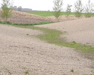
Mt Possession Station’s Donald Whyte steps lightly over an ankle-deep stream so glassy clear every nook and cranny can be seen.
The stream weaves its way down from a spring on a nearby small mound to the stock access point and beyond into Lake Denny on the station’s Hakatere block.
Mt Possession is part of Whyte Farming Company’s about 16,000ha, which includes its 2000ha Edendale deer farm park.
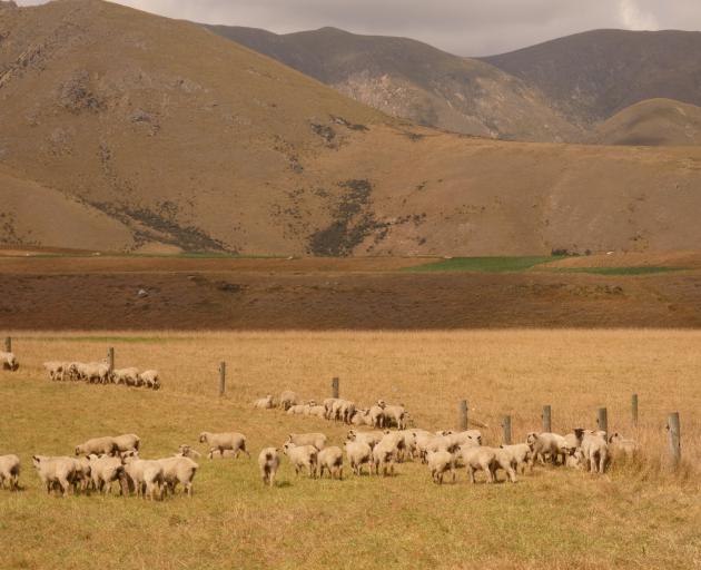
Most of this land falls within Mid Canterbury’s Ashburton Lakes catchment, an area prized for its back-country scenery and freshwater gems.
Outside the fenced-off stream, young lambs have their heads down grazing on developed paddocks. The dryland Pudding Valley block has been without stock since April and the lambs were put in only recently, after a cut of baleage was taken.
By every measure this would appear to be a typical high country farming scene.
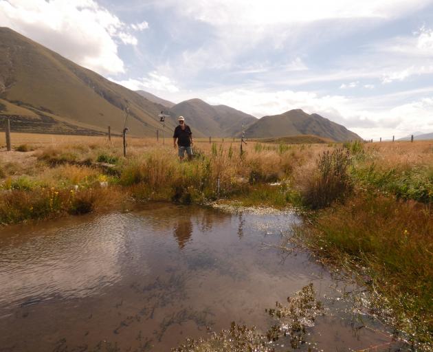
Except a closer inspection of the stream bank reveals small stations measuring and monitoring weather, turbidity and nitrate and sedimentation levels in the water.
The nitrate reader is a plastic tube lying in the creek, tracing nutrients passing through it, while the turbidity reader tracks the water’s cloudiness.
For good measure, a game camera provides a count of livestock numbers passing through the watery accessway.
This is the only drinking water source for the several hundred lambs in the next paddock .
Mr Whyte scrambles over a live fence. Landing squarely on his feet, he moves closer to the data-collecting technology.
Some of the readers monitor the crossing point for sedimentation stirred by passing lambs to see how far that moves downstream. Naturally, this spikes when they make their way across.
"Does it reach the lake? At this stage it’s not even reaching the next sensor," Mr Whyte says.
"But we want to know what’s going on here. This has always been one of my test sites and I test the stream up the top and the mid-point and going into the lake to see what the influence of the stock is grazing around here. This is the major permanent surface water that runs into the lake.
"There’s another stream by the scrub up there and I test that and I test another one. So I’m trying to get the whole picture of where all the surface water and any contamination that’s happening to find out what it means. Well, the water’s cleaner down there [pointing to the lake] than it is up here. And this water here has a lower nitrate level than a Pump water bottle coming out of a supermarket, and we know that because we tested them."
The Whyte family joined forces with Castle Ridge Station’s Paul and Kerry Harmer, Lake Heron’s Philip and Anne Todhunter and Mt Arrowsmith’s Philip and Wendy Wareing to form the Ashburton Lakes Catchment Group (ALCG) and work together in response to reviews for proposed rules on their land use consents.
They started water-quality testing for nitrates and other nutrients after feeling the finger was being pointed exclusively and unfairly at them for the lakes’ low water quality.
Their concern is an inflexible regulatory system will rely on rigid rules brought in from outside and fix on farming to make the lakes better rather than casting the net wider for all causes.
Water samples collected at test sites on each property go to a laboratory for analysis and are plotted on a computer to show trends.

After 21 months of testing, it’s been reassuring to learn the initial results show nutrients are 60% lower when they pass through farmland than entry points and it is not simply farming at play for low lake quality.
Oddly, some of the higher nitrate levels appear to be in springs often near the upper reaches of their farms.
This runs contrary to reports showing the main nutrient source across all lakes is from pastoral land use with minor sources including potential seepage of human wastewater at Lake Clearwater and Lake Camp, perhaps natural nitrogen such as fixation from clover and matagouri, as well as waterfowl waste at Lake Emma, Lake Denny and Lake Emily and potentially changes in climate-reducing inflows into the lakes and streams.
Mr Whyte points to the example of Lake Emma for poking holes in this argument.
This was taken out of farming by his father 26 years ago when he bought the lease from University of Canterbury and freeholded the land. A condition of this was the margin around Lake Emma and Lake Denny could not be farmed.
"So the way the land lies at Lake Emma, and its source of water, we can’t influence it at all with grazing or topdressing. Our closest stock are probably 200 metres away and the slope of the land means any grazing we have on the piece which is nearest runs the other way. But that lake water is still deteriorating on the Trophic Level Index (TLI)."
Lake Emma is one of the shallow lakes with swampy fringes and high in sediment, which has never met trophic levels under targets in the Canterbury Land and Water Regional Plan.
Mr Whyte accepts farming has changed the environment and land use in the valley over many years, along with European settlement and Maori before that. When his family first arrived, the paddocks leading to Lake Denny were undeveloped native grassland and fences were few and far between. This land has since been improved by them.
He was like every farmer in the area who did not want to see the lakes go backwards as they lived in the valley, but they were uneasy with the direction the review was heading, he said.
"It’s self-defence really. It was pretty obvious that the data being used against us was selective, so we needed to defend ourselves."
That’s why they took on the sampling of water passing through before, during and after their properties.
To do this the couples set aside half a day each month from their busy farming schedule, a costly and time-consuming exercise.
But interim results have encouraged them it is worthwhile.
Mr Whyte carries out water testing at about 10 sites on his farm, initially fortnightly and then monthly after trends started to emerge.
Samples are collected at four sites where the stream runs into Lake Denny. Each family has its own pet project looking at mitigating options for the group. For Mt Possession this is the feeding stream for the lake.
"The results so far have been bloody interesting and sort of mirrored by a number of the other sites in that water coming off that hill there — Mt Harper — has higher levels of nitrates than there is running through the paddocks and going into Lake Denny. The water’s not getting dirtier as it runs through the paddocks in many cases. I know our management system of stock and water isn’t causing the deteriorating water quality, contrary to what we are being told. We are being unfairly treated and our testing results are showing that."
Mt Harper is on Department of Conservation (Doc) land with no stock on its slopes.
Below it, the stream water was found to have "minuscule" levels of nitrate at 0.02 to 0.4 micrograms per litre. The Pump water measured more than two times higher.
This data goes to Hill Laboratories to be evaluated every second month with the group’s zone-committee funded $10,000 nitrate tester calibrated to its equipment to make sure the results are accurate.

E coli testing repeatedly shows levels in water coming from paddocks running into the lake, grazed mainly by sheep and some cattle, are low, but are often 20 times higher coming out of the lake because of the waterfowl.
Despite the hard scientific data, he worries the authorities will not listen and continue to pursue extremely low water quality targets in their consent, achievable only with significant changes to his farming management or complete removal of stock.
He fenced the spring coming out above the crossing 15 years ago.
Down one side of the creek was fenced years ago to keep cattle out and more lately he has reconfigured the fencing on both sides to keep all stock out.
Along the stream banks Carex secta has been planted by the catchment group, the plants provided by Synlait. The next stage will be extending the native planting up the banks to help keep ungrazed weeds down.
Inflexible rules based without hard data seemed to be the same for more intensive irrigated farm types with 10 to 15 times higher nitrate readings. Yet stocking rates at the valley stations was much lower and the targets failed to apply to their group’s extensive farming systems, he said.
"We are the first cab off the rank in the South Island high country that had to get consent to farm and this was a first for pastoral farming and it’s still that situation. We are prototyping something and if we get it wrong, every bugger behind us will get it as the rules will apply to them, as well. So that’s pretty serious from an individual point of view and across everybody. We’ve got to get it right."
Outside of farming, other issues appear to be at play for the lakes’ deterioration.
Historically, Lake Clearwater’s problems are also believed to be influenced by bach stormwater and decommissioned long-drop toilets. At Lake Denny and lake Emily waterfowl are acknowledged as more of a contributor than other lakes.
The ALCG farmers would like to see more science carried out on the effect of climate change on all the lakes and natural events such as the 2021 flooding, when a third of Ashburton River and Haast Stream ran into Maori Lakes.
Plant growth and its breakdown on Doc land and lake edges and natural processes on high spring heads on native country catchments seems to be overlooked.
The farming families question why they are being singled out unfairly in their consent conditions for removing all stock — sheep and cattle — from sensitive areas, when only cattle are restricted for the rest of New Zealand.
Mrs Harmer said they were worried limits would be unjustly set on overall stock numbers.
"That’s exactly our concern because at the moment ECan is not talking about decreasing stock numbers, but they have already indicated if the water quality doesn’t improve over the next five years that’s the sort of thing they would do. So, there’s no real appetite for looking at what the full problem is and finding actual solutions that will make a difference."
Castle Ridge Station’s creeks include the spring-fed Gentleman Smith stream running through their property and Jacob’s stream next to the homestead, both of which exit into Maori Lakes. Another unnamed stream with springs on the far side of the farm towards Arrowsmith is also water-tested, as is a small creek running into a wetland beside Lake Emily. The Harmers water-test the Doc boundary to this creek, below the wetland and where it flows into Jacob’s Creek.
Some of the spring heads come out on their property and others are on Doc land.
Mr Harmer said consistent trends had emerged from water sampling where the water came on to their property from neighbours or undeveloped and ungrazed Doc land and where it left their property.
"The main trend is probably the springs coming out of the ground are up a bit and by the time that water travels through the creeks and where they enter the lake it’s usually better. Most of that is because it’s going through the vegetation and tussocks and everything growing along the creek which helps to draw out any nutrients. Where the tricky bit is, and this needs more science and groundwater work to understand, why is it coming out of the ground higher? This is the big unknown."
They had been led to believe that farming was contributing to much of the lake degradation, he said.
Frustrating for them is even the nitrate levels in the springs are "way below" national drinking water standards, with the highest of them at 1.9 mg/l.
Mrs Harmer said it was questionable if the lakes’ TLI — a measure of ecological health based on nutrients and algae growth standards — would be ever reached, as a number of lakes had never, or rarely, met the targets set since recording began.
She said there were no wells between Castle Ridge and Mt Somers and with no groundwater research being carried out to provide answers, everyone was guessing at what they thought the water was doing, how far it went down before it hit a glacial pan and the lag time and distance before it surfaced.
She said the Castle Ridge streams were relatively stable and often low in nitrates.
One of the lowest at 0.002mg/l in the middle of their flat paddocks was essentially a water race which stock always had access to, yet there was no change in quality in the 21 months of testing.
Data shows stream quality neither goes up or down consistently in summer or winter, but nitrates tend to rise when it is drier and are lower after rain.
Mrs Harmer said the response from authorities so far was that valley farmers were 90% of the problem for nitrates, but water-test results indicated otherwise.
They were being lumped into the same intensive winter grazing for consent conditions as high-intensity farming down country from them, she said.
"We are being classed as intensive up here, but our stocking is about three stock units to the hectare for the whole place ... it’s higher on the flats, but it’s still not 20 stock units and that’s what you would class as high elsewhere."
She said the results were not all "good and rosy", as 40% of their tests showed nitrates went up slightly from starting in Doc land and going through farmland.
They wanted to find out why this was happening and have a tailored solution, rather than a blanket mitigation across their whole farm or across the catchment.
Changes they had made, at a cost to them, over many years included putting Italian ryegrass in winter feed crops, direct drilling crops, fencing off creeks and putting in riparian planting, changing their fertiliser use, reducing their nitrogen fertiliser amount on crops and moving winter crops further from creeks and removing cattle from some areas and retiring sensitive catchments either voluntarily or with the Crown.
Castle Ridge’s pet project is riparian planting and they are looking to introduce a wetland to deal with the high nitrate level spring heads.
Some winter feed crops of swedes and turnips are areas classed as hotspots.
However, the swede crop is usually four to 10 tonnes to the hectare, much lower than down-country crops.
Mrs Harmer said urine patches on their 60ha run-off paddock for their 250 beef cows were nowhere near as intensive as a mob of dairy cows grazing a smaller block.
At least a 5m buffer separates the paddocks from the creeks.
In the past five years they have progressively removed crops away from waterways where possible and reduced fertiliser rates.
"It’s made no difference to the water testing, but has made a massive difference to our crop yields. ECan is struggling to deal with the fact the leaching from our crops may be less than in other environments. We are getting blanket rules and recommendations for mitigations based on elsewhere."
At Mt Arrowsmith, scientists from Plant and Food Research, funded by the TR Ellet Trust, planted catch crops in oats and Italian ryegrass, and another in ryecorn and Italian ryegrass, after a winter feed crop of swedes and Italian ryegrass.
The plants appear to be initially absorbing more nutrients at a high rate and as they grow, they balance it out, with less chance of leaching as a result.
This year the catch crop will be grazed instead of being cut for silage, to see how it could fit into the normal farming system.
Mrs Harmer said the science was telling them that nitrogen leaching under winter feed crops was not happening as much as was being suggested.
She said the trial results would be shared with Ecan when Plant & Food scientists completed the second year of the trial and were satisfied, they had enough accuracy.
"The evidence is pretty clear we are not losing as much as people think," ALCG facilitator Phill Everest said.
He joined the group because he thought the valley’s farmers were getting a raw deal.
The plan was to tailor research into practical farming solutions rather than relying on systems designed for the Canterbury Plains.
Most of the project funding for the trial plots and lab costs for analysing the water samples has been provided by the Ministry for Primary Industries and the farmers were doing much of the grunt work.
Mr Everest said the four farming families were spending half a day on monthly samples to get a good base line.
They had followed standard protocol with the water tests and there was no ignoring the results.
"So that’s what we are struggling with. We are trying to get the science which we should already have and it doesn’t matter who’s to blame or not, but we are trying to get some background facts to establish the true picture."
More work was needed to fingerprint sources such as Mt Harper above Lake Denny, with its elevated nitrate concentrations, and more sampling could pinpoint where the nitrogen was coming from. This could be from rock weathering, animal urine, natural nitrogen fixation from plants, nitrogen fertiliser — although little was used — organic matter breakdown or other unexplained causes, he said.
Other potential influences could be hot water emerging out of some of the springs with higher nitrate levels than the farms, which was being investigated now. Where this comes from and the possible chemical reaction causing this no-one seems to know.
On the wish list is to match the water quality testing with temperature changes and rainfall and seasonal variations, to get a better overview.
During a big snow last year, the Harmers found the snow tested a higher nitrate reading than the lake target levels.
Another question mark hangs over testing at Lake Heron.
Water quality in the lake is going backwards and agencies are suggesting all farming should be removed from this valley.
The farming families have a theory that long lag times may be skewing results.

What the farmers would like to see from authorities is greater acceptance of the complexity of water quality causes in the lakes and across the catchment’s total of more than 100,000ha.
A widened scope should include many other natural and man-made sources.
"I actually think the dream result is we get accepted that there’s something else going on here and that farming in generalised terms isn’t harming the water up here," Mr Whyte said.
"There’s something else going on. How can we have both up here — good water and farming? I would be happy enough with that."
Response from Environment Canterbury
Environment Canterbury says it is working closely with Ōtūwharekai/Ashburton Lakes farmers through their working group and consenting process.
A council spokesman said there could be variability in monitoring results depending on the sites, attributes, timeframes and sampling methods as well as what was going on in the environment — as was the case with all complex natural systems.
"Our science team has met with the farmers to understand and discuss the methods used and the results obtained, how it compares to other data and any implications arising out of it."
He said an independent hearing commissioner would decide whether the consent applications/reviews for the properties would be notified in April.
Whether ECan factored in the results of water-sampling results by farmers in the Ashburton Lakes Catchment Group would be decided by the commissioner.
"We have not yet seen these results despite several requests."
Water quality targets were set through the Canterbury Land and Water Regional Plan development process. The limits were based on scientific advice and consulted on extensively, aimed at reducing the risk of degradation.
The current state of the lakes was a complex question but helpful information was available on ECan’s website.
The spokesman said the lakes remained at risk of eutrophication (excessive nutrients in the water) despite significant efforts put in to understanding and addressing the issues over at least the past 18 years.
"It is likely that the majority of the nutrients entering the lakes comes from the pastoral farming activity surrounding them, although there are other sources in the catchment too."
The Ministry for the Environment’s "Lessons Learned" report into the lakes states before human arrival, the lakes were clear and surrounded by forest with low inputs of sediment and nutrients.
ECan said climate change was likely to further increase the lakes’ vulnerability to eutrophication.
This highlighted the need for substantial and urgent action to prevent the Ashburton lakes from entering into, or remaining in, persistent degraded states.
ECan said it would like to acknowledge the Ōtūwharekai Working Group members for their ongoing work to understand and improve the health of the lakes and the basin together.