
All flights in and out of Wellington Airport have been cancelled due to the wild weather hammering the region today.
Wellington Airport says high winds are making it unsafe for baggage handlers to operate and MetService says gusts of up to 120kmh have been recorded there today.
Passengers have been advised to check directly with airlines for further information.
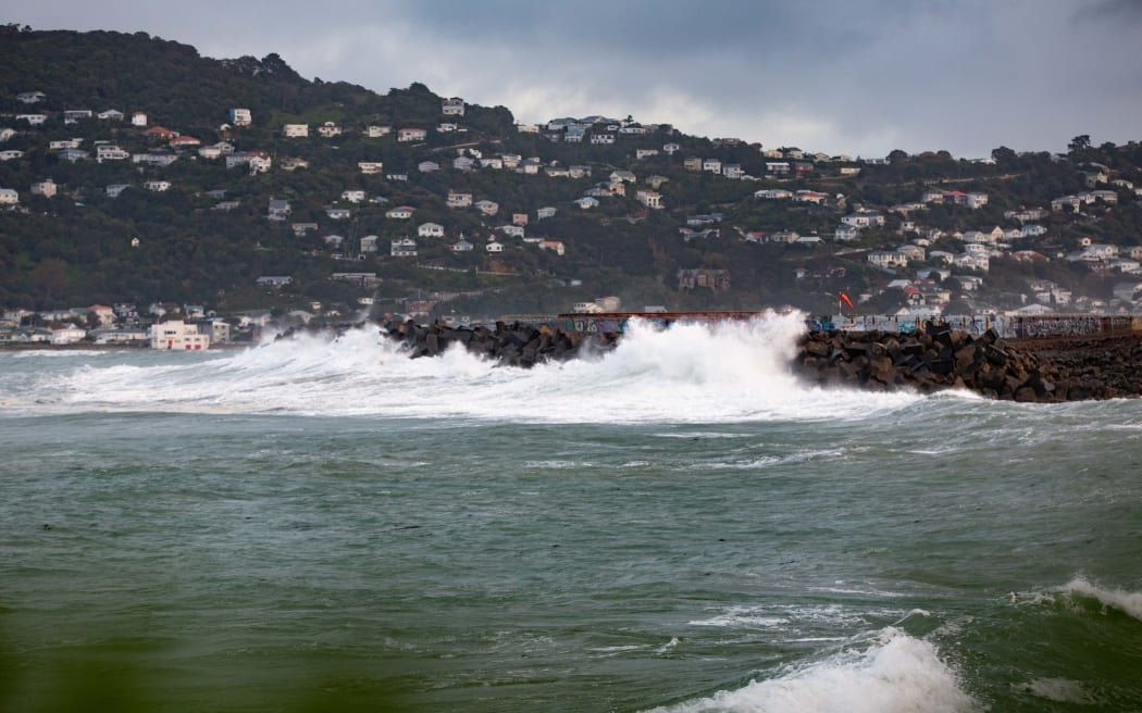
Ferry sailings have also been cancelled and seven-metre high waves were expected on the South Coast.
Wellington Region Emergency Management is urging surfers, swimmers, fishers and small boat owners to stay away from the sea.
The large swells have lead to the cancellation of ferry sailings across the Cook Strait with Interislander cancelling its 11am and 2.15pm sailings from Picton, as well as the 8.30pm sailing from Wellington.
Bluebridge has cancelled its 1.30pm and 8.30pm Wellington to Picton sailings, as well as the 2.00pm and 7.15pm Picton to Wellington crossings.
Motorists should avoid Marine Drive in the Eastbourne area because it had been closed due to waves crashing over the road, police said.
Regional manager Jeremy Holmes said 5m waves were expected from later this afternoon and they would increase to 7m waves early this evening.
By tomorrow morning the waves were expected to have dropped back to about 4m, he said.
"The good news is that the highest waves, the seven metre waves, are not expected to coincide with high tide and that's likely to be around midnight or the early hours of the morning.
"So we expect the impacts to be quite minimal in terms of inundation like we've seen in the past."
Despite that, the size of the waves meant that people were encouraged to stay away from the coastal area, Holmes said.
MetService had forecast southerly to south-westerly winds, but exactly when the winds would change and what direction they would come from was unclear at this stage, he said.
Dependant on wind direction different parts of the South Coast could be affected and Wellington Region Emergency Management is preparing for that, he said.
"So for example if you take for Ōwhiro Bay, obviously if it comes from a southerly direction then some parts will be affected, if it comes from the south-west then other parts will be affected.
"Likewise it's likely to affect Wellington harbour in a similar way - we're expecting an increase of between 10 and 20cm of water in the harbour during the course of the next day or so."
Depending on the wind direction that could mean different parts of the harbour are effected and it may hit places like Eastbourne and Petone, Holmes said.
He warned motorists in those areas to drive to the conditions, but said if people in those areas could work from home that would be preferable.
Bad weather also forecast for Wairarapa
MetService has a heavy rain warning in place for Wairarapa, south of Featherston, with up to 90mm expected to accumulate from 7am until 7pm tonight.
"That is likely to cause some surface flooding and possible slips in that part of the region," Holmes said.
It has also issued a strong wind warning for Wellington and Wairarapa from 10am this morning until 10pm tonight with gusts up to 130km/h forecast in exposed places.
"That's likely to potentially pose issues for particularly high sided vehicles and motorbikes," Holmes said.
There is also a snow warning in place for the lower Remutaka Range from 9am this morning until 3pm this afternoon.
That may mean there is some sleet on the Remutaka Hill Road, which combined with the wind could make driving treacherous, Holmes said.
Motorists urged to be cautious, plan ahead
The forecast big waves, high winds and snow in some places mean Waka Kotahi/ NZ Transport Agency is advising motorists to take extra care when driving today and to check their journey before they travel to ensure the roads are open.
Spokesperson Mark Owen said there is a severe weather warning along the eastern coast from Kaikōura right through to Gisborne.
"With rain forecast, strong winds, some snow on the inland mountain passes and also storm surges along the coast - so when you put all that together there's quite significant weather impact to a number of parts of New Zealand."
Motorists should plan ahead because there is a risk of road closure with snow forecast for the Desert Road and the Remutaka Hill Road, Owen said.
Waka Kotahi will have crews on stand-by to deal with any issues caused by the snow, he said.
"We'd just ask people to, particularly with it being school holidays and moving around across the country, just allow extra time. But before you go just check that the road and route you're taking is open."
Motorists also need to be cautious using any coastal roads due to the forecast storm surges which potentially could throw debris onto the road or undermine it, Owen said.


