A heavy rain watch has been issued for Dunedin and Clutha tonight as heavy rain and strong winds batter much of the country.
Periods of heavy rain are expected from 8pm Thursday until 8am Friday.
New heavy rain warnings have also been issued overnight for Southland and the Southern Lakes area.
In Southland, another 25-40mm of rain is expected, on top of what has already fallen, particularly in the region's west.
Similar amounts are expected in the Southern Lakes area.
In Marlborough, two stopbanks protecting a small settlement are at "catastrophic" risk of failure as the deluge that has battered the West Coast moves north.
Repairs and upgrades of the stopbanks - along Peninsula Road in Spring Creek - are expected to cost $8.7 million.
The stopbanks are critical for protecting the township of about 600 people. The town is also near State Highway 1 and KiwiRail's main north line.
One of the stopbanks started showing signs of cracking after the 2016 Kaikōura earthquake. Cracks started to appear in the lower section of the other one in the July 2021 floods.
More than 800 millimetres of rain has fallen in parts of Westland district since Tuesday.
Two West Coast rivers are currently peaking well over their warning levels.
The Hokitika River is more than a metre over it's warning level in the gorge, and was expected to peak at 7pm.
The alert level is 3.7m - at 7.05pm, West Coast Regional Council measured it at 4.9m.
It's flowing fast and is being closely monitored by West Coast Emergency Management.
The Waiho River in Franz Josef peaked at 6.20pm, half a metre over its alert level.
But it has since been dropping.
West Coast Emergency Management has told residents to prepare for flooding, and to be prepared to evacuate if needed.
Some parts of the West Coast have lost cell phone coverage due to a network fault.
Westland Mayor Helen Lash said Spark and 2degrees networks were out in South Westland.
Lash says the Emergency Operation Centre has been told the outage is due to a network fault, not the weather.
111 calls are unaffected, and crews are on the ground working to get the network back up as soon as possible.
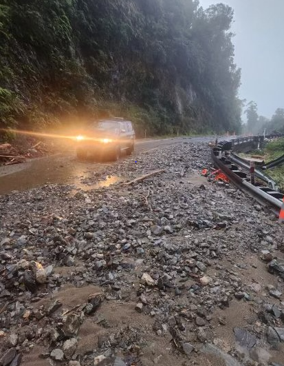
State Highway 6 was closed between Haast and Ross at about 5pm, owing to surface flooding and slips along the highway
Fox Glacier remains cut off by slips to the south and a washout north.
SH6 will remain closed between Fox Glacier and Franz Josef over the weekend.
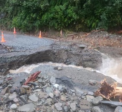
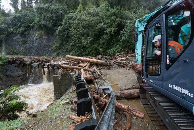
NZ Transport Agency Waka Kotahi said the washout was at Smithy's Creek, on State Highway 6 between Franz Josef and Fox Glacier.
"Creek flows have breached the southern approach at the Smithy’s Creek box culvert overnight Wednesday with the continuous heavy rain," NZTA's Moira Whinham said.
Crews were on standby to start repairs as soon as conditions were safe for them to do so, Whinham said.
The highway is also closed between Fox Glacier and Haast, near Paringa, owing to several slips and fallen trees.
As heavy rain and high winds are forecast to continue, the highway will remain closed today and overnight, NZTA says.
The closures either side of Fox Glacier means the township is cut off from vehicle access.
NZTA said SH6 was open between Makarora and Haast, but would close again at 7pm until 10am tomorrow, due to ongoing heavy rain.
A business owner in Fox Glacier says tourists have mostly cleared out of the township.
He said locals were not very worried.
"We get a lot of rain and slips are pretty common.
"We've got extra resources and emergency services here so we're well prepared."
Fire and Emergency NZ said they had only responded to a small number of weather-related callouts since noon yesterday.
Rivers still rising
Westland Mayor Helen Lash said rivers were continuing to rise throughout the district.
With the ground now sodden after 450mm of rain yesterday, water was running off the land and straight into the rivers, she said.
Lash told RNZ's Midday Report there were no plans and no need for evacuations at present.
She said the pinch times would be about 5pm for Franz Josef and a few hours later for Hokitika.
With the heaviest rain expected this afternoon, West Coast Emergency Management is urging people to stay up-to-date with radio news and on its Facebook page.
Te Aroha Cook, group controller West Coast Emergency Management said: “We are starting to see impacts particularly to the roading network. We continue to work closely with our partner agencies to ensure we can respond to any further impacts. The Emergency Operations Centre remains staffed 24 hours a day and is undertaking significant planning to assist the community where it’s needed.”
Sandbags available, power out for several days for some
Cook said power was expected to be out for several days in areas south of Hannahs Clearing, including Arawhata, Jackson Bay and Neils Beach after three power poles went down.
In central Hokitika, sandbags are available for residents to protect their homes and businesses from surface flooding.
She said the Jacksons Bay road, below Haast, had also been closed due to flooding.
MetService earlier said up to 450mm of rain hit Westland on Wednesday and another 350mm was forecast by 9pm today.
As the deluge continues on the Coast, weather warnings have been issued for much of the North Island as well.
MetService this morning issued a slew of weather advisories, covering most of the South Island and much of the upper North Island.
They include heavy rain warnings for Fiordland, Southland and the Otago Lakes headwaters, and road snow warnings for the Crown Range Road and the Milford Road (State Highway 94) overnight into Friday.
There was still a chance the current orange warning would be upgraded to red, he said.
"There's a definite risk of flash flooding and it's hazardous conditions for driving so anyone in the area should keep up to date with the forecast."
RNZ reporter Maia Ingoe is in Franz Josef and said about 8.30am the rain was getting heavier and there was some surface flooding in low-lying areas.
A relentless downpour nearing 20mm/hour rate is expected.
She said high tides after midday could cause some concern for residents in Hokitika and Ōkārito, who had been getting prepared with sandbags,
MetService's Mmathapelo Makgabutlane said the bottom of the South Island was also expected to receive heavy rain and strong winds today, while eastern areas could expect rain later today.
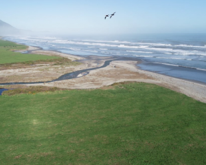
She said people in the settlement of Bluecliffs should be alert.
"The thing about that part of the country is that they don't quite need very high rainfall numbers like we see on the West Coast, to start seeing those impacts. Definitely a good one to keep a close eye on."
While today's temperatures would be warm, she said tomorrow "we see a switch".
"We could even see some snowfall in some elevated areas, plenty to keep an eye on over the next 24 hours."
- additional reporting ODT Online