Christchurch and Dunedin look set for a drenching going into the weekend, while heavy snow could hit parts of inland Otago.
MetService this morning updated its weather advisories to include a heavy rain watch for Dunedin and North Otago, for 19 hours from 2pm on Friday.
There is also a heavy snow watch for Central Otago and the Canterbury High Country south of the Rangitata River, for 11 hours from 11pm on Friday.
The forecast is for periods of heavy snow above 600 metres, where snowfall amounts may approach warning criteria.
MetService said an active front, preceded by heavy rain and north to northwest gales, was moving across the upper South Island today, reaching the North Island on Friday.
The forecaster said a low off the South Island's east coast was expected to bring heavy rain to Christchurch, Dunedin and North Otago.
The front has prompted a slew of weather alerts for the top of the South Island and parts of the North Island.
The Tasman District Council is expecting rivers across the region to be running at high levels, warning residents to prepare for flooding.
Heavy rain, thunderstorms, gales and possible flooding is forecast for much of the South Island.
Tasman District Council said uncertainty about the forecast and possible thunderstorms meant people should plan for flooding.
Council hydrologists said 75 to 140mm of rain had already fallen in the Tasman ranges in the last 12 hours.
The Tākaka River and its tributaries and the Aorere River had peaked or were about to peak, all below annual flood flows.
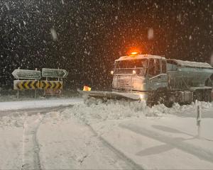
The rain is already being felt in some places. Haast Pass (State Highway 6) was closed for several hours between Haast and Makarora because of a slip, and violent winds hit parts of Canterbury overnight.
NZ Transport Agency Waka Kotahi said about 10.15am that the highway had reopened "but more rain, strong winds and potential snow may cause further disruption on South Island roads over the next couple of days".
MetService meteorologist Heather Keats said there was "pretty decent rainfall and strong winds come through the South Island overnight as expected".
The Canterbury High Country experienced "massive" 250km/h wind gusts.
"But that's a very elevated site that's quite exposed."
Other sites saw 90kmh gusts, while some areas also had 10mm to 20mm of rain hourly.
"At the moment everything's playing out as we expected as that really active front does start to track over the South Island."
The Marlborough District Council said the forecast rain was uncertain, and the possible impact "difficult to predict".
The weather system had the potential to stall, delivering additional rainfall on Friday, leading to a more significant weather event, the council and Marlborough Emergency Management said in a statement on Wednesday.
With school holidays looming, Keats said: "Sunday looks amazing" while ski fields would benefit from fresh snowfalls over the next few days.
- ODT Online/RNZ