Toitū te whenua - Māori Place Names Series
EPISODE 1
EPISODE 2
EPISODE 3
EPISODE 4
EPISODE 5
EPISODE 6
Place names tell us where we are and where we might want to go. They help us find our way. But place names are also important signposts of history, culture and identity.
Māori place names tell stories of creation, ancestors, explorers and events. They describe the landscape and identify resources. In this way, they recount history and record relationships between people and the land.
Moves to restore Māori place names have gained momentum alongside the revitalisation of te reo Māori and a deepening appreciation of the importance of the language to national identity.
Just as a grasp of te reo Māori let us see the world in new ways. Māori place names unlock stories left by those who have walked this way before us.
Māori place names ground us in the whenua and therefore our shared identity. As they recount history, they provide a new sense of belonging.
By recording the earliest relationships of people and places, they celebrate New Zealand's unique identity
In this series, we embark on a journey to retrace the footsteps of Māori who explored these lands.
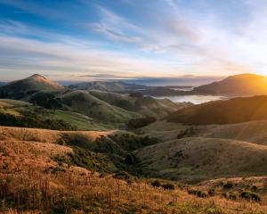
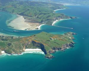
We find ourselves in the breathtaking Ōtākou region, a land rich in history, culture, and natural beauty.
Here in Ōtākou, Māori have traversed these lands for centuries, utilizing the bountiful nature as both a resource and a companion on their remarkable journeys.
In times long past, Māori communities flourished in what is now the city of Dunedin, residing in settlements around and along the harbour, relying on the ocean and the since-drained lakes for food and resources.
Their travels often took them inland to retrieve and trade pounamu.
Using an ancient route passed down through generations, they would journey along the Mata-au River as a lifeline, providing both sustenance and navigation.
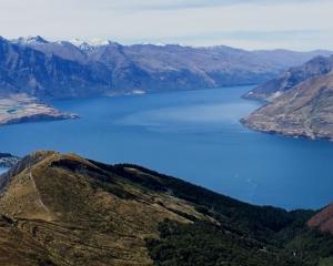
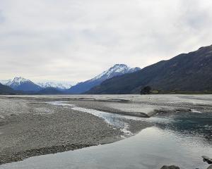
They encountered great lakes such as Lake Whakatipu-wai-Māori , Lake Hawea, and Lake Wānaka. Māori had settlements around these lakes, strategically placed for their expeditions to Mount Te Koroka, a sacred site rich in pounamu.
The journey's end was signaled by the prominent Mount Pikirakatahi, otherwise known as Mt Earnslaw, which pointed Māori to the pounamu in Te Koroka.
These mountains and lakes are steeped in stories and legends, each holding a unique place in Māori history and culture.
The Ōtākou region, with its Māori place names and deep-rooted histories, serves as a testament to the enduring connection between the Māori people and the land that sustained them. It is a reminder of the rich tapestry of stories, traditions, and cultural significance that continues to shape this remarkable part of Aotearoa, New Zealand.
Our expedition will begin at mount Pikirakatahi, leading us through the lakes and following the Mata-au River back to Ōtepoti.
Join us as we delve into our heritage, restoring the power of names, and rediscovering the connections between our people and the landscapes that nurture our stories.
Toitū te whenua - Māori Place Names Series (captioned)
EPISODE 2
Even today you must make something of an effort to arrive at the foot of Pikirakatahi.
It rises to dominate the skyline on the drive northwest from Tāhuna Queenstown, when following the shore of Whakatipu-wai-māori.
Its massive twin schist peaks sit high beyond Paradise, ringed around by the Dart and Rees Rivers, preserving a sense of the unassailable.
But people have been coming here a long time.
It is country first travelled by Rākaihautū, the captain of the waka Uruao, countless generations ago.
In pūrākau, Rākaihautū did more than just explore Te Waipounamu, the South Island, he shaped it with his legendary kō, or wooden spade, Tuwhakaroria.
In doing so, he mapped a whole host of important landmarks and resources that continued to shape the connection between Māori and the whenua. Among these, Pikirakatahi has a special place because of its relationship to that tino taonga, pounamu.
As recorded in the Ngāi Tahu Settlement, the origins of the name Pikirakatahi have been lost to time — and indeed many now know the mountain as Mt Earnslaw.
However, its importance is far from forgotten.
‘‘Pikirakatahi was of crucial significance to the many generations that journeyed to that end of Whakatipu-wai-māori (Lake Wakatipu) and beyond,’’ the iwi’s settlement Act records. ‘‘Staging camps for the retrieval of pounamu were located at the base of the mountain, while semi-permanent settlements related to the pounamu trade were located closer to the lake.’’
It is far from the only place pounamu is found in Te Waipounamu, but for the East Coast peoples of the South it is particularly important as a source within their takiwā.
Pounamu was used for myriad purposes. It was excellent for tools, adzes, chisels and the like, which could then be used to shape waka or whare.
It also made for beautiful ornaments, adornments and gifts, and could be traded as a commodity. And, of course, it was important for the manufacture of weapons.
Such is the mana of the mountain it is covered by a topuni, a protective cloak, under the Ngāi Tahu Claims Settlement Act 1998.
The Act records that during its formation, a wedge of pounamu was inserted into Pikirakatahi and the mountain now stands as kaitiaki (guardian) over the pounamu resource and marks the end of a trail, acting as a signpost to the pounamu resource.
The mauri of Pikirakatahi represents the essence that binds the physical and spiritual elements of all things together, the Act says, ‘‘generating and upholding all life’’.
All elements of the natural environment possess a life force, and all forms of life are related, it says.
‘‘For Ngāi Tahu, traditions such as these represent the links between the cosmological world of the gods and present generations, these histories reinforce tribal identity and solidarity, and continuity between generations, and document the events which shaped the environment of Te Wai Pounamu and Ngāi Tahu as an iwi.’’
EPISODE 3
As in all things, water is fundamental to the stories of Te Wai Pounamu, claiming a central role in its very name.
The voyagers who first arrived here did so by sea, and soon set out around its coast, exploring its waterways and reservoirs as extensions of their pathways across the moana.
But in pūrākau, those earliest discovers did more than simply map and track the layout of the new land, they took a direct hand in its creation, including many of the lakes for which the motu is known.
Among the first footprints Māori made in Te Wai Pounamu were those of the crew of Uruao, the ocean-going waka of the rangatira Rākaihautū.
Having navigated their way from Hawaiki, Rākaihautū and his crew found themselves at the northern end of the southern land mass, Te Tauihu-o-te-Waka.
Ōtākou Rūnaka upoko Edward Ellison confirms the history.
‘‘We have many waka atua, or ancestral god-like canoes in our histories, but the Uruao was captained by Rākaihautū and he landed on the boulder banks by Nelson,’’ he says.
Having arrived at Te Wai Pounamu, Rākaihautū and his son Rokohouia split up, Rākaihautū venturing down through the centre of the island while Rokohouia took Uruao down the east coast to explore and find good places to settle.
‘‘Rākaihautū in the meantime journeyed down through the centre of the island and our memory of that journey is recorded in the lakes and the maunga that he named — or in some accounts created with his digging stick, his ko, know as Tuwhakaroria,’’ Ellison says.
The route ticked off Rotoroa and Rotoiti in what is now the Nelson Lakes District, then south to Takapo (Tekapo).
‘‘They came upon that at night, hence the way he named that lake,’’ Ellison says.
Pō means night.
He continued on to Pūkakī, named Aoraki on his way past, visited Ōhau and named the lake Hāwea for a member of his party.
‘‘It’s a name that comes down through the whanau still to this day,’’ Ellison says.
‘‘Then he come across on to Lake Wānaka and they stopped there to conduct ceremonies to fortify themselves both spiritually and physically — hence the name Wānaka.’’
Eventally, Rākaihautū and his crewmates from Uruao made their way to Whakatipu Waimāori — digging it with the kō Tuwhakaroria
‘‘So, there are all these colourful stories talking about the coldness of the water in those places.’’
Waka and mokihi (rafts) were used by Māori to navigate the vastness of Whakatipu Waimāori and were the key modes of transport for the collection and trading of pounamu.
Tauraka waka, landing places for waka, were set up along the shores and on islands, such the islands Mātau and Wāwāhi Waka — otherwise known as Pig Island and Pigeon Island respectively.
As the Ngāi Tahu Claims Settlement Act 1998 records, Whakatipu Waimāori supported several permanent settlements, such as the kāika (village) Tahuna near present-day Queenstown, Te Kirikiri Pā, located where the Queenstown gardens are found today, a Ngāti Mamoe kaika near the Kawarau Falls called Ō Te Roto, and another called Takerehaka near Kingston.
For Māori, the lake was more than a body of water, it was the core of a network of trails that ensured their safety on journeys inland.
There is no direct translation of Whakatipu. ‘‘Whaka’’ is a prefix that often indicates the cause of an action, and tipu means to grow or to prosper. In other translations, tipu could be derived from the word tipua, which refers to a monster or supernatural being. Wai māori means fresh water, water you can consume, water that sustains life.
‘‘Thus it is a puna (spring) which sustains many ecosystems important to Ngāi Tahu,’’ the Settlement Act says. ‘‘The mauri of Whakatipu-wai-māori represents the essence that binds the physical and spiritual elements of all things together, generating and upholding all life.’’
Whakatipu Waimāori has also been said to mean the growing bay or the bay of spirits. Some have referred to the lake as the lake that breathes, because even though it is landlocked, it has it own tides that rise and fall through the day.
There are many stories connected to Whakatipu Waimāori.
Near Kawarau lived a monster named Kopuwai.
He tied a girl named Kaiamio to his leg at night, but she cleverly replaced herself with a log and escaped on a flax raft.
When Kopuwai discovered the deception, he swallowed so much water in anger that the Kawarau River emptied, leaving only a rocky bed.
Today, Kopuwai is the Obelisk rock on the Old Man Range, and Kaiamio is the nearby lagoon.
But perhaps the most famous story involves Hakitekura, the daughter of Kāti Māmoe chief Tuwiriroa
The Queenstown Gardens peninsula was once a Kāti Māmoe pā site.
The women of the village would often have swimming competitions in lake Whakatipu Waimāori and Hakitekura would watch them from a hill near Bob’s Peak
Determined to outdo them all, she asked her father for kindling and dry raupō or bulrush.
Early one morning, she bound them together with flax and tied the bundle to her back
Using Cecil and Walter Peaks as her guide, as the sunrise twinkled over the mountain tops, she set out into the lake, swimming a distance of 3km.
When she made it to Refuge Point, she lit a fire using the kindling and dry raupō.
In the morning, her village saw the fire smoke and her father knew it was her.
In honour of her bravery, the peak from which she had planned her swim was named Te Taumata O Hakitekura, the viewing place of Hakitekura.
Refuge Point was named Te Ahi-a-Hakitekura, meaning the burning flames of Hakitekura
Cecil and Walter Peaks were named Kakamu-a-Hakitekura meaning the twinklings seen by Hakitekura .
Māori made their way to these lakes from the coast using the awa Mata-au, otherwise known as the Clutha river, as their guide.
The name Mata-au is said to translate to surface current, presumably in reference to the small swirling currents seen on it’s surface.
The awa was a lifeline for Ōtākou hapu, providing mahinga kai along their travels to retrieve pounamu. It functioned as a fishery, home to an abundance of tuna, kanakana and kōkopu.
Food resources were especially plentiful at the river’s Kā Moana Haehae, the point where the Mata-au meets the Manuherikia.
The river also became an important boundary marker between Ngāi Tahu and Ngāti Mamoe. Ngāti Mamoe were to hold mana (authority) over the lands south of the river and Ngāi Tahu were to hold mana northwards — though over time marriages between the two overcame the division.
Having tracked the length of Te Wai Pounamu, Rākaihautū returned northeast from Te Ara a Kiwa, Foveaux Strait, to hit the coast near Balclutha, Ellison says.
At that time the lake there, Roto-nui-a-Whatu (Lake Tuakitoto), was much bigger, he says.
‘‘From there he went on to Waihora, Waipouri.’’
The former is known as Waihola today, but its correct name is Waihora — which means spread out (hora) water. Waipōuri, currently mispelt as Waipori, is so named because of the dark (pōuri) colour of that water coming out of the forested hills, the tanin in the water.
Travelling north he named Kaikarae (Kaikorai) for a bird, a karae, they cooked there, then finally arrived at Waihao where he met up with his son again.
‘‘The hao is a particular kind of eel found there,’’ Ellison says.
Finally, they settled at Akaroa, and its work done, Rākaihautū jammed his ko, Tuwhakaroria, into the ridge.
‘‘So, if you are at Akaroa and you are looking almost due west, you will see along the ridge a tor, something like a tor that is leaning, poking, jutting out of the ridge. That is said to be Tuwhakaroria in the ridge, renamed Tuhiraki.’’
All these stories are a way of remembering whakapapa, Ellison says.
You recite your whakapapa and pass that on to new generations, the fabulous stories working as an aid to memory, he says.
That world view, handed down in kōrero, frames the environment and explains it to us.
‘‘How we are here, and how we relate to the whenua, to the wai, to ngahere, to ngā manu, to ngā ika, to our enviornment, it goes right back to the kōrero of Raki and Papa — or in our case, Rakinui had more than one wife, Poko-harua-te-pō.
‘‘We have atua or demigods assigned through this creation story starting from the time of nothingness, through to the emergence of light, the arrival of water, and then life forms, they are all explanable in our traditions. So, there is no one god in that kōrero, there are many.
‘‘So, there was a whanaungatanga relationship, because we descend eventually from particular lines from Rakinui and Papatūānuku down to ourselves. So there is a whanaungatanga, a connectedness, or a connectedness that then governs how we work with our environment, how we live with it, respect it, take from it, give back, and have tikanga or rules that keeps the balance.’’
As such, the waterways and water bodies of the South, the Mata-au, the lakes, embody a way of seeing the world.
At the same time, they are a record of the practical business of living in the land.
Whakatipu Waimāori, named by the tupuna Rākaihautū, stands as a testament to ancient expeditions. Its shores were home to the mobile lifestyles of Māori, and helped shape a network of trails and landing places. The awa Mata-au served as a highway, while also providing resources and sustenance to those who embarked on its journey.
Together, Whakatipu Waimāori and the Mata-au remain as guardians of history, connecting whanau and hapu to their ancestral roots.
Etched into the land, their stories speak of resilience, tradition, and the enduring relationship between the people and their whenua.
EPISODE 4