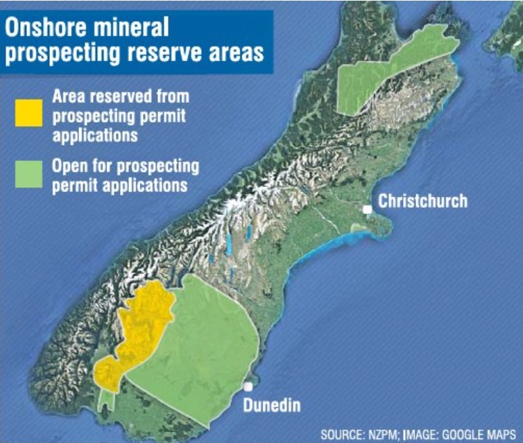
This week government permitting agency New Zealand Petroleum & Minerals (NZPM) reopened most of the 33,000sq km area in Otago and Northern Southland and 7828sq km across Nelson-Marlborough, to applications for mineral prospecting.
Conservation Minister Eugenie Sage moved to quickly reassure environmentalists the Government was still moving towards its proposed law change, and ultimately a "no new mines on conservation land" policy, as announced by Prime Minister Jacinda Ardern last year.
Both southern areas had been closed to prospecting applications since July 2015 while the government undertook airborne aeromagnetic surveys and geochemical sampling, at a cost of about $6million.
Both areas have always overlapped with conservation land, including reserves, conservation areas, or stewardship land, and national parks.
In Otago, the overlap includes the conservation areas Rock and Pillar, Oteake and Te Papanui, while in Marlborough, the permit area includes forest parks of Mt Richmond and Victoria and parts of Kahurangi and Nelson Lakes National Parks.
Forest and Bird chief executive Kevin Hague labelled the reopening of the areas as "political sabotage", given the Government had last year pledged "no new mines on conservation land".
"It beggars belief to deliberately undo the closure just before consultation is planned on how to protect these areas from mining.
"The Government has already announced no new mines on conservation land," Mr Hague said yesterday.
Almost 30% of the country is conservation land, but not all of it comes under the highest protection - Schedule 4 land - which protects national parks from mining.
Ms Sage was contacted for comment and said the timing of the moratorium ending was "unfortunate", given work was still under way on the proposed "no new mines on conservation land" policy.
She said the status quo applied to permitting until the law changes, through the finalising and implementing of the no new mines policy, with the consultation document yet to be released and public consultation sought.
"Having a prospecting permit from the Ministry of Business, Innovation and Employment does not guarantee that the Department of Conservation will grant access to conservation land," Ms Sage said.
Before access was allowed to conservation land for prospecting, exploration or any mining activity, the impacts of the activity on conservation values would be considered, such as unique ecosystems and wildlife, she said.
Mr Hague said 40,000 people marching in Auckland in 2010 had made it "pretty clear" the public did not want mining on conservation land.
"To even stand a chance of protecting our unique plants and animals we need our publicly owned conservation land to be used for conservation, not digging huge holes in the ground.
"Mining should occur outside of the conservation estate," he said.
Ms Sage said while mining was prohibited on Schedule 4 land, minimum-impact activities such as geological, geochemical and geophysical surveying were permitted under the Crown Minerals Act.
"Taking samples by hand or hand-held methods is also permitted," she said.
NZPM commercial analysis and investment manager David Darby said the agency was now accepting applications for prospecting permits across both the southern areas, except Central Otago where data acquisition was not yet complete, over an area of less than 3000sq km.
"Acreage will be allocated on a first-come first-served basis.
"The first application to meet the criteria for an acceptable work programme will be granted the permit for the area," Mr Darby said.
During the three-year moratorium, several boutique gold-mining operations in the South were stalled in their ability to apply for new prospecting permits.
In December 2017, the aerial survey to assess the wider Queenstown Lakes district's mineral deposits and geology got under way, covering a total 12,750sq km, ranging from Wanaka to Nightcaps.
The magnetic and radiation-sensitive surveys, done by helicopter and light plane, were not only looking for prospective mineral deposits but also for new information on fault lines, aquifers and soils, which could assist with plans for land use, environmental planning and engineering and construction projects.
Former explorer Glass Earth Gold spent about $40million on gold exploration around Otago in the early 2000s. In 2007, Glass Earth put up $3million for a 1.3million ha aeromagnetic survey of Otago, alongside $1million from the Otago Regional Council, the results being released in October 2011.
About 440ha of new conservation land was created yesterday, when Ms Sage announced land in the Mackenzie Basin had been transferred from Land Information New Zealand to the Department of Conservation, in order to protect a giant native grasshopper which is only found in the basin.
At a glance
Prospecting: A permit to look for specified minerals, restricted to low-impact activities such as aerial surveys, geological mapping and surface-rock and soil sampling by hand.
● At present 113 approved mining operations on conservation land; 54 are active. Includes coal, alluvial gold and gravel extraction, mainly on the West Coast, Otago and Coromandel.


